2.9 km away
Union Meadows GREEN

Far traverse out to the Green line with a short steep couple turns where most don't make it.
Moderate Freeride Skiing
- Distance
- 882 m
- Ascent
- 1 m
- Descent
- 128 m
Series of 6 chutes (H1 - H6) that vary dramatically in difficulty
Freeride Skiing Severe

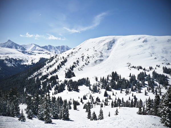
The Hemlock Chutes (H Chutes) area is pretty much the last zone that you're recommended to hike out to in Copper's adjacent Jacque Peak Backcountry zone. These chutes vary significantly in difficulty. The 3 chutes furthest skiers' left chutes are short but a lot of fun. They simply require a cornice drop-in and a little bit of rock avoidance towards the bottom half before merging with the massive bowl. The 3 chutes furthest skiers' right get progressively more challenging. The farthest chute skiers' right can be classified as extreme as it requires a mandatory straight-line or corniced-cliff drop depending on conditions. Although, all of these chutes share the quality of being quite short, making them a lot less challenging than you'd expect. Once you finish, merge onto the adjacent Farside run and follow a long traverse back
Severe
Steep skiing at 38-45 degrees. This requires very good technique and the risk of falling has serious consequences.

As well as the slope itself, there are some obstacles (such as rock outcrops) which could aggravate injury.

Little chance of being seen or helped in case of an accident.
2.9 km away
Far traverse out to the Green line with a short steep couple turns where most don't make it.
Moderate Freeride Skiing
3.1 km away

Rarely skied gladed trees.
Moderate Freeride Skiing
3.2 km away

Ski into the steepest pitch for a few turns off West Ridge.
Severe Freeride Skiing
3.3 km away

Hidden tree glades with natural wind features.
Moderate Freeride Skiing
3.3 km away

Rarely skied gladed trees in Union Meadows.
Moderate Freeride Skiing
3.3 km away

Quick access to banked tree runs with natural features
Moderate Freeride Skiing
3.8 km away

A steep open face to trees, and one of the most aesthetic lines at Copper Mountain.
Difficult Freeride Skiing
4 km away

The Hollywood Line just above the American Flyer Lift
Difficult Freeride Skiing
9.4 km away

Short Bowl descent off the Southside of Peak 6
Difficult Freeride Skiing
9.5 km away

Steep rock filled line
Extreme Freeride Skiing
3 routes · Freeride Skiing