228 m away
Knot Slot

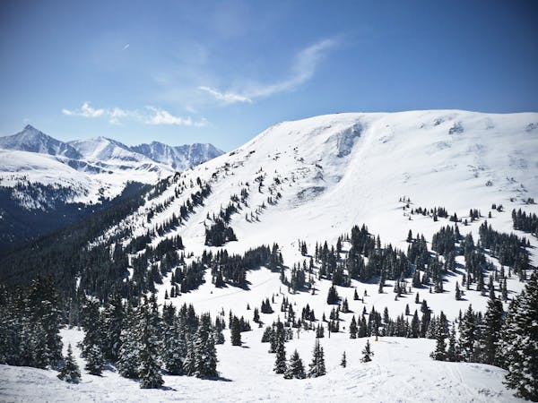
Ski into the steepest pitch for a few turns off West Ridge.
Severe Freeride Skiing
- Distance
- 416 m
- Ascent
- 0 m
- Descent
- 143 m
Run that leads into the Jacque Peak Backcountry Area
Freeride Skiing Difficult

This run takes a good bit of traversing to reach from the T-Bar. Once you make it to the end of the face and exit through the gate, you'll be greeted with this steep and enjoyable face. It is a steep run though it mellows out very quickly and this run will set you up nicely to hike to ski all the technical alpine runs off Jacque Peak
Difficult
Serious gradient of 30-38 degrees where a real risk of slipping exists.

As well as the slope itself, there are some obstacles (such as rock outcrops) which could aggravate injury.
Away from help but easily accessed.
228 m away
Ski into the steepest pitch for a few turns off West Ridge.
Severe Freeride Skiing
257 m away

Rarely skied gladed trees in Union Meadows.
Moderate Freeride Skiing
258 m away

Hidden tree glades with natural wind features.
Moderate Freeride Skiing
258 m away

Quick access to banked tree runs with natural features
Moderate Freeride Skiing
377 m away

Rarely skied gladed trees.
Moderate Freeride Skiing
533 m away

Far traverse out to the Green line with a short steep couple turns where most don't make it.
Moderate Freeride Skiing
836 m away

The Hollywood Line just above the American Flyer Lift
Difficult Freeride Skiing
1.5 km away

A steep open face to trees, and one of the most aesthetic lines at Copper Mountain.
Difficult Freeride Skiing
6.1 km away

Short Bowl descent off the Southside of Peak 6
Difficult Freeride Skiing
6.3 km away

Steep line with zero shaped rock garden in it
Extreme Freeride Skiing
3 routes · Freeride Skiing