1.2 km away
Snowslide Lake
Steep jaunt up to a lake with opportunities for fishing, camping, and further hikes into the mountains.
Moderate Hiking
- Distance
- 5.2 km
- Ascent
- 404 m
- Descent
- 404 m
A steep trail crossing bouldery meadows and mountain creeks, leading to a large lake hidden high in the mountains.
Hiking Difficult

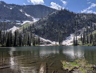
Box Lake is one of the largest alpine lakes in the mountains near McCall. Its long shoreline provides a lot of room for camping, fishing, and swimming. The lake sits in a high, broad basin of green and gray, surrounded by granite peaks.
The hike to Box Lake begins from Lick Creek Road, where there's a signed trailhead with limited parking. This hike is quite popular on summer weekends, so try to arrive early to secure a spot.
The first mile is perhaps the toughest part of the hike, as the trail takes steep switchbacks with loose footing, but at least it's in the forest with decent shade. Higher up, the trail becomes less steep and leads through sunny meadows which are studded with granite boulders and interlaced with patches of forest. There are some creeks to cross and downed logs to climb over, but the trail remains well defined even though it's rugged.
After a final steep and rocky section, the trail reaches a pass and crosses an especially verdant meadow, then reaches a spectacular overlook of the lake. From there, it descends on switchbacks to reach the shore.
The lake level varies with the season, and by late summer it's usually shrunk enough to reveal a sandy beach on the south end. No matter the amount of water, comfortable backcountry campsites can be found all along the west shore, which is where the trail leads. Camping is allowed without a permit, but you must choose from established sites that have clearly been used before, and heed any fire restrictions which may be in place. Note also that this portion of trail on the west edge of the lake is open to motorcycles, which can get there from the nearby Crestline Trail. The rest of the trail, between Lick Creek Road and the south shore of the lake, remains non-motorized.
Sources: https://www.fs.usda.gov/recarea/payette/recreation/recarea/?recid=27401&actid=50 https://visitmccall.org/hiking-guide-box-lake/
Difficult
Hiking trails where obstacles such as rocks or roots are prevalent. Some obstacles can require care to step over or around. At times, the trail can be worn and eroded. The grade of the trail is generally quite steep, and can often lead to strenuous hiking.

The trail contains some obstacles such as outcroppings and rock which could cause injury.

Little chance of being seen or helped in case of an accident.
1.2 km away
Steep jaunt up to a lake with opportunities for fishing, camping, and further hikes into the mountains.
Moderate Hiking
1.2 km away

Combo of the two 8000+ foot peaks above Snowslide Lake.
Extreme Hiking