Snowslide Lake
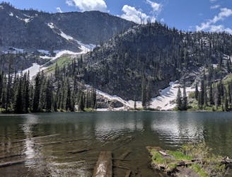
Steep jaunt up to a lake with opportunities for fishing, camping, and further hikes into the mountains.
Moderate Hiking
- Distance
- 5.2 km
- Ascent
- 404 m
- Descent
- 404 m
Combo of the two 8000+ foot peaks above Snowslide Lake.
Hiking Extreme

Snowslide Lake is a popular spot for day hikes, fishing, and backpacking. Most people go just to the lake and turn around, but the trail continues up and over the pass called Snowslide Summit. From that pass you can forge off trail to tag one or both of the summits above the lake.
The nearer and lower of the two is Snowslide Peak (8,522 ft). Its sheer north face is what forms the imposing backdrop of Snowslide Lake, but the northeast ridge provides a manageable route to the summit. You may choose to go straight up the ridgeline, which is the more adventurous option requiring 3rd and 4th class scrambling. Or you can work your way along the tamer south face of the ridge, using benches and talus slopes to traverse and then scramble up when you're directly beneath the summit. There is no trail and no cairns, so it's really a choose-your-own adventure to the top.
Sawtooth Peak (8,875 ft) is higher and farther away, but is actually the easier ascent in terms of terrain. It's primarily a hike and boulder hop out the ridge, with no scrambling required if you choose your route carefully. There is the option for some exciting exposure along the spine, but safer passage can be found by staying just to the right (east) of the crest. Again, there is no trail and no cairns. Please try to keep it that way by leaving no trace.
Extreme
Scrambling up mountains and along technical trails with moderate fall exposure. Handholds are necessary to navigate the trail in its entirety, although they are not necessary at all times. Some obstacles can be very large and difficult to navigate, and the grades can often be near-vertical. The challenge of the trail and the steepness of the grade results in very strenuous hiking. Hikes of this difficulty blur the lines between "hiking" and "climbing".

Some trail sections have exposed ledges or steep ascents/descents where falling could cause serious injury.
Little chance of being seen or helped in case of an accident.
Steep jaunt up to a lake with opportunities for fishing, camping, and further hikes into the mountains.
Moderate Hiking
1.2 km away

A steep trail crossing bouldery meadows and mountain creeks, leading to a large lake hidden high in the mountains.
Difficult Hiking