1 m away
Pearly Gates
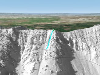
Short hourglass shaped run
Difficult Freeride Skiing
- Distance
- 214 m
- Ascent
- 0 m
- Descent
- 137 m
Short, steep chute where the Bridger hike and Patrol lift are
Freeride Skiing Difficult

This is a popular freeride skiing route which is generally considered to be difficult. It's remote, it features low exposure (e1) and is typically done between October and June. From a low point of 2.5 km to the maximum altitude of 2.6 km, the route covers 224 m, 0 vertical metres of ascent and 136 vertical metres of descent. It's graded 3.2 and Labande grade 3.
Patrolman's is a steep narrow chute where the Bridger hike and Patrol lift are located. The general public should not ski this during the operating season. It is a little bit wider at the crux than Pearly Gates, but also a little steeper.
Difficult
Serious gradient of 30-38 degrees where a real risk of slipping exists.

Exposure is limited to that of the slope itself. Getting hurt is still likely if the slope is steep and/or the snow is hard.

Away from help but easily accessed.
1 m away
Short hourglass shaped run
Difficult Freeride Skiing
12 m away

Long, tight, steep chute into an open apron
Severe Freeride Skiing
52 m away

Extreme, tight, steep chute with an air out of the bottom
Severe Freeride Skiing
55 m away

Wide, consistent, short East facing run
Difficult Freeride Skiing
96 m away

Steep, rocky, winding chute
Severe Freeride Skiing
104 m away

Great rolly sheltered tree run
Difficult Freeride Skiing
106 m away

Steep, decently wide North facing chute
Difficult Freeride Skiing
123 m away

Easy way to get into the apron of Sometimes/ Lewis and Clark/ Cuckoo's
Moderate Freeride Skiing
125 m away

Quick tight chute to medium sized fast air
Severe Freeride Skiing
138 m away

Quick, powdery, North facer
Difficult Freeride Skiing