47 m away
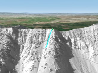
Cuckoo's

Open snowfield to a tight fast chute
Severe Freeride Skiing
- Distance
- 166 m
- Ascent
- 0 m
- Descent
- 103 m
Steep, rocky, winding chute
Freeride Skiing Severe

Lewis and Clark is a great run, but can be pretty rocky, especially in the early and mid seasons. It doesn't get alot of sun, so the snow usually stays pretty decent. It does get controlled frequently, so all the fresh powder may be sluffed out. Head North down the ridge from the Bridger hike. Right as the ridge flattens out, head down and right. You will get awesome turns for about 100ft in flat, spaced trees. As it steepens out, you have two options for entrance. Right is a North facing wide shoulder, but can be pretty rocky; left is a more direct route, but is a little tighter. Once in, you can hop turn it pretty easily, dodging all the rocks that litter the chute. If the snow hasn't been sluffed out, you could just go for it and point it. Lewis and Clark has a slight left turn at the bottom, just before running out into the apron, but it's not too drastic. Another option is to take a moderate sized air off the cliff on the skier's left just before the last turn. Once out, you'll be at the top of the apron that this line shares with Sometimes and Cuckoo's.
Severe
Steep skiing at 38-45 degrees. This requires very good technique and the risk of falling has serious consequences.

As well as the slope itself, there are some obstacles (such as rock outcrops) which could aggravate injury.
Away from help but easily accessed.
47 m away
Open snowfield to a tight fast chute
Severe Freeride Skiing
84 m away

Long, tight, steep chute into an open apron
Severe Freeride Skiing
94 m away

Extreme, tight, steep chute with an air out of the bottom
Severe Freeride Skiing
96 m away

Short, steep chute where the Bridger hike and Patrol lift are
Difficult Freeride Skiing
97 m away
Short hourglass shaped run
Difficult Freeride Skiing
143 m away

Quick tight chute to medium sized fast air
Severe Freeride Skiing
145 m away

Wide, consistent, short East facing run
Difficult Freeride Skiing
155 m away

Easy way to get into the apron of Sometimes/ Lewis and Clark/ Cuckoo's
Moderate Freeride Skiing
164 m away

Steep, decently wide North facing chute
Difficult Freeride Skiing
181 m away

Complex tight chutes and open snowfields
Difficult Freeride Skiing