5.8 km away
Appalachian Trail: Franconia Notch to Crawford Notch
A perfect segment to shuttle, bagging several 4,000-footers along the way.
Severe Hiking
- Distance
- 40 km
- Ascent
- 2.5 km
- Descent
- 2.6 km
White Mountains National Park
Hiking Difficult

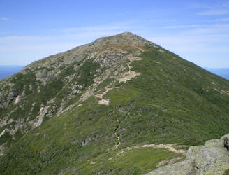
If you didn’t make it to Mount Lafayette yesterday, you will today. This stage is under seven miles long and doesn’t look impressive on a map, but looks are deceiving. After summiting Mount Lafayette, you’ll be challenged by the frequent ups and downs and rough trail conditions of the Garfield Ridge Trail. Expect at least 5 hours of hiking time over 2,700 feet (823 meters) of elevation gain. But the view of the surrounding Pemigewasset Wilderness from the top of Mount Lafayette, the highest peak in the Franconia Ridge (5,260 feet / 1,603 meters), is superb and makes the pain worth it. Cap the day off at the Galehead Hut, the most remote of the AMC huts, surrounded by untouched wilderness.
www.pygmy-elephant.com
Difficult
Hiking trails where obstacles such as rocks or roots are prevalent. Some obstacles can require care to step over or around. At times, the trail can be worn and eroded. The grade of the trail is generally quite steep, and can often lead to strenuous hiking.

The trail contains some obstacles such as outcroppings and rock which could cause injury.
Away from help but easily accessed.
5.8 km away
A perfect segment to shuttle, bagging several 4,000-footers along the way.
Severe Hiking

58 routes · Hiking

25 routes · Alpine Climbing · Hiking

10 routes · Hiking