6.8 km away
Appalachian Trail: Oliverian Notch to Franconia Notch
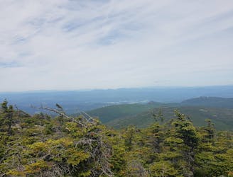
Summiting Mount Moosilauke and Mount Kinsman via the Appalachian Trail
Severe Hiking
- Distance
- 36 km
- Ascent
- 2.6 km
- Descent
- 2.5 km
Loop through the Mount Moosilauke woods
Hiking Difficult

This is a popular hiking route which is generally considered to be difficult. It's very remote, it features medium exposure and is typically done between April and November. From a low point of 723 m to the maximum altitude of 1.5 km, the route covers 15 km, 808 vertical metres of ascent and 809 vertical metres of descent.
Located of of Sawyer Highway near Lincoln, NH, this loop brings you to the top of one of New Hampshire's 4000 footers.
Difficult
Hiking trails where obstacles such as rocks or roots are prevalent. Some obstacles can require care to step over or around. At times, the trail can be worn and eroded. The grade of the trail is generally quite steep, and can often lead to strenuous hiking.

The trail contains some obstacles such as outcroppings and rock which could cause injury.

Little chance of being seen or helped in case of an accident.
6.8 km away
Summiting Mount Moosilauke and Mount Kinsman via the Appalachian Trail
Severe Hiking

58 routes · Hiking