2.5 km away
Appalachian Trail: Crawford Notch to Pinkham Notch
Summit the highest peak in the northeast, Mount Washington.
Severe Hiking
- Distance
- 37 km
- Ascent
- 2.6 km
- Descent
- 2.4 km
Out and back trail to the top of Mount Webster and Mount Jackson
Hiking Difficult

This is a popular hiking route which is generally considered to be difficult. It's very remote, it features high exposure and is typically done between March and November. From a low point of 370 m to the maximum altitude of 1.2 km, the route covers 18 km, 1081 vertical metres of ascent and 1081 vertical metres of descent.
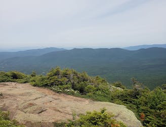
This trail is a moderately trafficked out and back trail located near Bartlett, NH, and takes you to the top of Mount Webster and Mount Jackson. It's a great forest setting and is used primarily for hiking, nature trips, and bird watching.
Difficult
Hiking trails where obstacles such as rocks or roots are prevalent. Some obstacles can require care to step over or around. At times, the trail can be worn and eroded. The grade of the trail is generally quite steep, and can often lead to strenuous hiking.

Some trail sections have exposed ledges or steep ascents/descents where falling could cause serious injury.
Little chance of being seen or helped in case of an accident.
2.5 km away
Summit the highest peak in the northeast, Mount Washington.
Severe Hiking

58 routes · Hiking