9.1 km away
Appalachian Trail: Franconia Notch to Crawford Notch
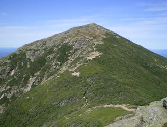
A perfect segment to shuttle, bagging several 4,000-footers along the way.
Severe Hiking
- Distance
- 40 km
- Ascent
- 2.5 km
- Descent
- 2.6 km
Difficult loop out of Lincoln, NH connecting many of New Hampshire's 4000 footers.
Hiking Severe

Located near Lincoln, NH, and connecting some of New Hampshire's 4000 footers. It's a long and difficult trail so make sure you have enough food, water, and experience. The trail goes across the Franconia Ridge, over to South Twin Mountain, and also to the top of Mount Bond. Great for checking off some of your 4000 footers.
Severe
Hiking challenging trails where simple scrambling, with the occasional use of the hands, is a distinct possibility. The trails are often filled with all manner of obstacles both small and large, and the hills are very steep. Obstacles and challenges are often unexpected and can be unpredictable.

Some trail sections are extremely exposed where falling will almost certainly result in serious injury or death.

Little chance of being seen or helped in case of an accident.
9.1 km away
A perfect segment to shuttle, bagging several 4,000-footers along the way.
Severe Hiking

58 routes · Hiking

25 routes · Alpine Climbing · Hiking

10 routes · Hiking