1.4 km away
119 + 2

A very steep and technical cliff that requires mandatory air.
Severe Freeride Skiing
- Distance
- 191 m
- Ascent
- 0 m
- Descent
- 83 m
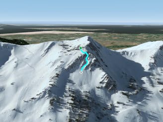
20-30 Minute Hike To Steep Chute Off Mt Ogden
Freeride Skiing Severe

This is a popular freeride skiing route which is generally considered to be severe. It's very remote, it features high exposure (e3) and is typically done between December and February. From a low point of 2.7 km to the maximum altitude of 2.9 km, the route covers 722 m, 59 vertical metres of ascent and 248 vertical metres of descent. It's graded 4.3 and Labande grade 5.
Big Mountain Skiing Really Fun On Powder Days
Severe
Steep skiing at 38-45 degrees. This requires very good technique and the risk of falling has serious consequences.

In case of a fall, death is highly likely.
Little chance of being seen or helped in case of an accident.
1.4 km away
A very steep and technical cliff that requires mandatory air.
Severe Freeride Skiing
1.5 km away

A small boot-pack leads to a must-hit powder stash.
Difficult Freeride Skiing
1.6 km away

A run that has incredible rewards for little effort.
Difficult Freeride Skiing
2 km away

A hidden bowl usually stocked with fresh lines. Recommended for experienced skiers.
Difficult Freeride Skiing
2.1 km away
A steep and technical chute that spills out into a powdery bowl.
Extreme Freeride Skiing
2.1 km away

A hidden powder stash that consistently offers deep shots throughout the entire season.
Moderate Freeride Skiing
3.1 km away

Long turns, fresh lines, and deep powder.
Moderate Freeride Skiing
8 routes · Freeride Skiing · Ski Touring