59 m away
Angel Food

One of the most popular hardwood glades in The Notch
Moderate Freeride Skiing
- Distance
- 2.9 km
- Ascent
- 183 m
- Descent
- 558 m
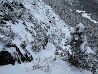
A frozen riverbed that’s almost as wide as a ski trail.
Freeride Skiing Moderate

The Riverbed is no secret, in fact it’s one of the most popular unmarked glades on the mountain. But that doesn’t make it any less of a treat. As you ski down Chin Clip, look to skiers right. About half way down you’ll see a sideslip entrance into a tight little gully. From here, it looks deceptively difficult. But after you enter, it opens up into a 12-14 foot wide gully. Changes are you’ll see other people skiing it as well. There are a few small mandatory ice cliffs that are easy to negotiate. About half way down you’ll see an orange rope, this was put here to prevent skiers from sending it off a large waterfall into a pool of water. Traverse out of the riverbed into the woods to the right. From there you can ski a wide hardwood glade called Whitewater or cut back into The Riverbed. Both options end on Chin Clip Runout.
Moderate
Slopes become slightly steeper at around 25-30 degrees.

As well as the slope itself, there are some obstacles (such as rock outcrops) which could aggravate injury.

Close to help in case of emergency.
59 m away
One of the most popular hardwood glades in The Notch
Moderate Freeride Skiing
361 m away

A summer hiking trail that requires serious tree skiing skills to negotiate.
Moderate Freeride Skiing
644 m away

Long, steep glade runs, involving cliffs and chutes.
Severe Freeride Skiing
657 m away

Climbing Gully serves as the approach for Mount Mansfield, but it also makes a great ski line.
Difficult Freeride Skiing
712 m away

A popular glade involving a mandatory icefall
Moderate Freeride Skiing
767 m away

A long traverse, under a massive icefall leads to some fun low angle glades
Moderate Freeride Skiing
1 km away

A very straight forward chute, directly above the Gondola.
Difficult Freeride Skiing
1 km away

A complex mess of boulders, trees and chutes that makes perfect freerider terrain.
Severe Freeride Skiing
1 km away
A hero line with wild exposure
Extreme Freeride Skiing
1 km away

The most popular descent on Mount Mansfield.
Difficult Freeride Skiing
12 routes · Freeride Skiing