350 m away
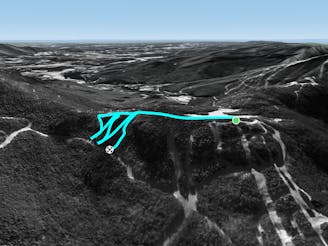
Smugglers Notch Crossover

A low angle trail used to cross from Spruce Peak to Sterling Peak and to access the Back Bowls.
Easy Freeride Skiing
- Distance
- 867 m
- Ascent
- 17 m
- Descent
- 68 m
It's a climbing trail like hell brook but harder.
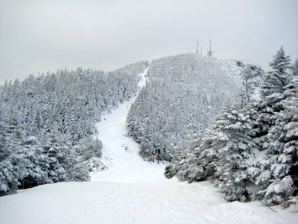
Freeride Skiing Severe

This is a popular freeride skiing route which is generally considered to be severe. It's very remote, it features medium exposure (e2) and is typically done between January and February. From a low point of 510 m to the maximum altitude of 934 m, the route covers 934 m, 0 vertical metres of ascent and 425 vertical metres of descent. It's graded 4.1 and Labande grade 4. You'll need rope to complete it safely.
It's a difficult, narrow, long, rockslide.
Severe
Steep skiing at 38-45 degrees. This requires very good technique and the risk of falling has serious consequences.

As well as the slope itself, there are some obstacles (such as rock outcrops) which could aggravate injury.

Little chance of being seen or helped in case of an accident.
350 m away
A low angle trail used to cross from Spruce Peak to Sterling Peak and to access the Back Bowls.
Easy Freeride Skiing
560 m away

A short little stash off Cross Cut #2
Moderate Freeride Skiing
722 m away

A favorite backcountry zone among locals.
Moderate Freeride Skiing
767 m away

A massive backcountry glade with a number of drop ins
Difficult Freeride Skiing
1.2 km away
A short hike/sidestep some wide side country glades.
Difficult Freeride Skiing
1.3 km away

A handful of turns through unmarked woods.
Moderate Freeride Skiing
1.4 km away

A tight glade skiers right of Smugglers Alley.
Moderate Freeride Skiing
1.6 km away

Long, steep glade runs, involving cliffs and chutes.
Severe Freeride Skiing
1.6 km away

The inbounds continuation of Hershey Highway.
Moderate Freeride Skiing
2.1 km away

One of the most popular hardwood glades in The Notch
Moderate Freeride Skiing
12 routes · Freeride Skiing