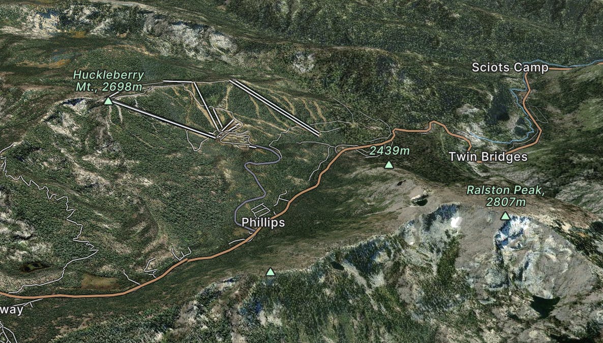
Miles 1048.8-1092.3 of the northbound PCT: Approaching Lake Tahoe through a mosaic of volcanic peaks and granite mounds, with mountainside meadows and alpine lakes around every turn.
Moderate Hiking
- Distance
- 69 km
- Ascent
- 2.2 km
- Descent
- 2.6 km

A classic backcountry-style IMBA Epic ride.
Severe Mountain Biking
- Distance
- 58 km
- Ascent
- 1.7 km
- Descent
- 2.3 km

Explore a patchwork of forests, meadows, and lakes in the Upper Truckee River Basin south of Lake Tahoe.
Difficult Hiking
- Distance
- 27 km
- Ascent
- 1 km
- Descent
- 968 m

You'll want to ask a local guide to take you through this route
Moderate Freeride Skiing
- Distance
- 592 m
- Ascent
- 0 m
- Descent
- 166 m

Entry level tree runs
Easy Freeride Skiing
- Distance
- 950 m
- Ascent
- 0 m
- Descent
- 208 m

Consider asking a local guide to take you through this route
Easy Freeride Skiing
- Distance
- 4 km
- Ascent
- 25 m
- Descent
- 417 m

Ask a local guide to take you through this route!
Severe Freeride Skiing
- Distance
- 628 m
- Ascent
- 0 m
- Descent
- 166 m

You should ask a local guide to take you through this route
Moderate Freeride Skiing
- Distance
- 576 m
- Ascent
- 3 m
- Descent
- 111 m

Lots of bumps and obstacles to make your own
Moderate Freeride Skiing
- Distance
- 1.3 km
- Ascent
- 0 m
- Descent
- 409 m

Ask a local guide to take you through this route
Difficult Freeride Skiing
- Distance
- 947 m
- Ascent
- 1 m
- Descent
- 269 m

A step up from Pyramid trees
Moderate Freeride Skiing
- Distance
- 1.1 km
- Ascent
- 0 m
- Descent
- 234 m

A joy in good conditions
Moderate Freeride Skiing
- Distance
- 582 m
- Ascent
- 0 m
- Descent
- 161 m

A tricky, but rewarding line into Upper Dynamite
Severe Freeride Skiing
- Distance
- 1.5 km
- Ascent
- 0 m
- Descent
- 456 m

Hollywood line
Severe Freeride Skiing
- Distance
- 615 m
- Ascent
- 0 m
- Descent
- 232 m

A fun traverse style route
Moderate Freeride Skiing
- Distance
- 1.6 km
- Ascent
- 0 m
- Descent
- 283 m

A fun, north facing aspect with mellow tree skiing and playful terrain features with an easy hike in and out. Located above Lower and Upper Echo Lakes near Echo Summit and High Way 50.
Difficult Ski Touring
- Distance
- 5.1 km
- Ascent
- 300 m
- Descent
- 347 m