1 m away
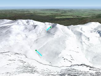
Carruther's Shoulder SE

At a couple of kilometres long, these runs offer long consistent slopes for intermediates, that hold around 300 metres of vertical.
Moderate Freeride Skiing
- Distance
- 1.8 km
- Ascent
- 4 m
- Descent
- 313 m
A steep series of chutes, with over 400 metres of vertical on offer.
Freeride Skiing Difficult

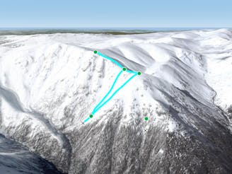
The chutes on the north side of Carruthers Peak are magnificent, with long lines down to James Macarthur Creek, with lines further west starting at a lower elevation, but gaining the vertical lower down. This area consists of a number of rocky chutes and narrow gullies, with the western end holding larger rocky crags, whilst further towards the peak and the east, the gullies and chutes catch more snow. Due to the northern aspect, these runs lose snow quickly in spring, and as a result of their rocky nature, they require a lot of snow to get started, thus it is advisable to consider this area when there is a base of 1 metre at Spencer's Creek. All of the lines available are steep and consistent in grade down to the creek, which is skiable in a good year too, in high season, you can choose any of the lines on offer but it is always a good idea to scout your line first, from vantage points like Tenison Woods Knoll. The easiest way to return after getting down to James Macarthur Creek is the ridgeline which leads up to the east on the other side of the creek is one option, with the gullies either side of the chutes another. Take care of snow conditions, and one of the best times to ski this area is early spring.
Difficult
Serious gradient of 30-38 degrees where a real risk of slipping exists.

As well as the slope itself, there are some obstacles (such as rock outcrops) which could aggravate injury.

Little chance of being seen or helped in case of an accident.
1 m away
At a couple of kilometres long, these runs offer long consistent slopes for intermediates, that hold around 300 metres of vertical.
Moderate Freeride Skiing
1 m away

One of the easier routes down from Carruthers Peak to Club Lake.
Difficult Freeride Skiing
1 m away

The "easiest" descent into Club Lake from Carruther's Peak
Difficult Freeride Skiing
2 m away

Consistently steep, cross graded at times and challenging. With a cliff on the side to show off to your mates.
Difficult Freeride Skiing
2 m away

Only skiable in above average years, providing similar characteristics to Route 3, just add a very very steep drop.
Difficult Freeride Skiing
2 m away

Route 3, or "The Elevator" is aptly named. Steep and intimidating, this is the most obvious line from Carruthers Peak.
Difficult Freeride Skiing
95 m away

Providing around 400 metres of continuous vertical, this run gives more margin for error compared to the rocky chutes to the west.
Difficult Freeride Skiing
184 m away

West and slightly to the south, Little Austria provides some incredible skiing, and is a locals' favourite.
Moderate Freeride Skiing
395 m away
A great way from Club Lake to milk a few more sweet turns before heading back home to Charlotte's Pass.
Moderate Freeride Skiing
454 m away
Similar to the West Face, this area can provide great skiing with decent vertical
Difficult Freeride Skiing