9.3 km away
Wanglspitze
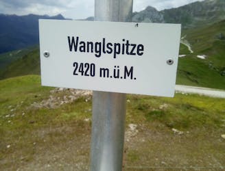
A fun little peak with exceptional views.
Moderate Hiking
- Distance
- 10 km
- Ascent
- 522 m
- Descent
- 522 m
Hut to hut hike, stage of the Inntaler Hohenweg, easy and nice
Hiking Moderate

This is a popular hiking route which is generally considered to be moderate. It's not remote, it features low exposure and is typically done between June and September. From a low point of 1.7 km to the maximum altitude of 2.5 km, the route covers 12 km, 892 vertical metres of ascent and 667 vertical metres of descent.
Moderate trail fo condition, easy technically, Kovenzjoch has nice views
Moderate
Hiking along trails with some uneven terrain and small hills. Small rocks and roots may be present.

The path is on completely flat land and potential injury is limited to falling over.
Close to help in case of emergency.
9.3 km away
A fun little peak with exceptional views.
Moderate Hiking
9.7 km away
A gorgeous, easy stroll along a famous ridge line.
Moderate Hiking
3 routes · Hiking
3 routes · Hiking