289 m away
Cascade Mountain Normal Route
Hike and scramble to the top of an impressive peak just outside the town of Banff.
Extreme Hiking
- Distance
- 19 km
- Ascent
- 1.6 km
- Descent
- 1.6 km
CascadeMountain, hiking the mythical Mountain of Banff
Hiking Severe

VIDEO: https://youtu.be/XuoDvLIQRk
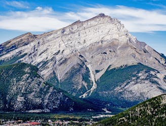
ENGLISH https://www.cnotremonde.com/en/itineraries/alberta-en/cascade-mountain-alberta-2-eng An epic hike on a mythical mountain! Hiking Cascade Mountain, icon of the Canadian Rockies, is a real adventure. The pyramid-looking mountain is 2998 meters high (9836 ft) and is located in Banff National Park. It is the famous mountain overlooking the city of Banff (right in the perspective of Banff Ave). The trail that goes to the top is not to be underestimated: Long distance, major elevation gain and a scrambling section at the final push to the summit. This is a difficult hike offering a great variety of terrain (forest, scree…) and panorama that is worth all the effort. C’est Notre Monde explains to you how to climb this unique mountain overlooking the famous city of Banff.
DIRECTIONS The hike starts right at the parking lot. You will have to cross the ski station following a large gravel road and reach the river down the valley, where your climb will actually start. So follow the road until you reach the last ski lift, around 1.13km (0.7 mi) from the parking lot. Then, take the small trail going in the forest on your right and follow it until you reach a wooden bridge crossing Forty Mile Creek. Do not be surprised, at this point, the trail was either flat or going down.
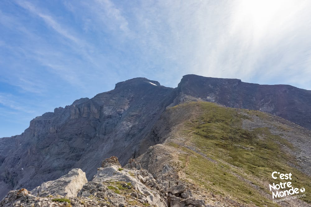
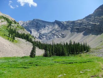
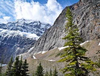
Things are finally getting serious. Once the bridge is crossed, the trail will start climbing gradually and will not stop until you reach the summit. The climb within the forest is 3.7km long (2.3 mi), until you reach Cascade Cirque at around 2140m high. The Cirque is a beautiful opening in the center of the mountain, marking the transition between the hiking and the scrambling parts. From there, you will be able to see your final objective, Cascade’s summit, 860m (2822 ft) higher. At the Cirque, you will have already gained 615 meters (2019 ft) of elevation.
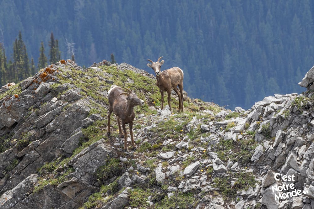
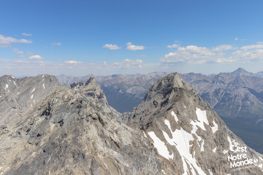
Take the trail on the right of the Cirque and start the second part of your ascent. The trail is already steeper and the terrain more and more Rocky. You will quickly reach a large scree section that needs to be crossed. The trail is no longer clearly identifiable as you have to make your way through big Rocks. You can however use the small kairns to make sure you are on the right way. You will then reach a “flat” part allowing you to reach the summit ridge further away. The view from this part is beautiful: You are overlooking the Cirque on one side and seeing the city of Banff on the other. If you are lucky, you can also spot marmots and wild goats.
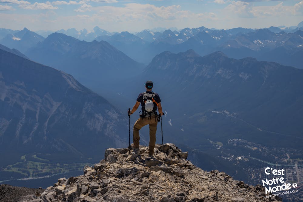
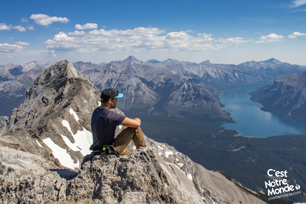
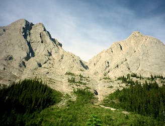
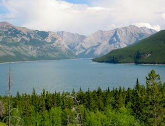
You will then start the final section of your climb, considered as an “intermediate scrambling” by Alan Kane in his famous guide book “Scrambling in the Canadian Rockies”. Continue on the trail and go around the false summit by stepping down a small rock step. Be careful and do not attempt to climb the false summit, the confusion is very easy. You will then reach a small section a little bit exposed to reach the bottom of the final climb. The summit is in front of you, 250 meters higher (822 ft). Take your time and climb this last steep section to reach the top of Cascade Mountain, at 2998 meters-high. The view of Banff and Lake Minewanka from the summit is breathtaking. You can also see Mounts Rundle, Temple, Assiniboine and Big Sister. All the iconing mountains of the region.
Retrace your steps to get back to the parking lot.
FRANÇAIS https://www.cnotremonde.com/randonnees/alberta/cascade-mountain-alberta-2 Une montagne mythique pour une randonnée qui l’est tout autant ! L’ascension de Cascade Mountain, icône des Rocheuses Canadiennes, est une vraie aventure. Cette montagne pyramidale de 2998m (9836 ft) se situe dans la parc national de Banff et est connue surplomber la ville de Banff (en plein axe de la Banff avenue). Le sentier qui mène à son sommet n’est pas à prendre à la légère : La distance est longue, le dénivelé élevé, et une partie de scrambling vient compliquer l’approche finale. C’est donc une randonnée difficile mais dont la diversité du terrain et des panoramas méritent indubitablement l’effort. C’est Notre Monde t’explique comment gravir cette montagne unique surplombant la ville de Banff.
ITINÉRAIRE Le départ se situe sur le stationnement de la station de ski de Norquay. La première partie de la randonnée consiste à traverser la dite station et de rejoindre la rivière au fond de la vallée, afin de démarrer l’ascension. Traverse donc le complexe de ski en passant devant toutes les remontées mécaniques sur un chemin assez large. Après 1.13 km (0.7 mi), un sentier s’engouffre dans la forêt sur la droite. Il se situe après la dernière remontée mécanique. Suis le sur 1.8 km (1.13 mi) jusqu’à rejoindre un pont en bois, traversant la rivière Forty Mile Creek. Ne sois pas surpris, à ce stade de la rando, tu n’auras fait que du plat ou de la descente.
C’est alors que les choses sérieuses commencent. Une fois le pont traversé, le sentier commence à monter graduellement et ne s’arrêtera qu’au sommet. La montée en forêt va s’étendre sur environ 3.7 km (2.3 mi) pour atteindre Cascade Cirque à 2140m d’altitude. Le cirque est une magnifique ouverture au centre de la montagne, marquant une transition entre la partie “randonnée” et la partie “scrambling”. Tu pourras d’ailleurs y voir le sommet qui se situe environ 860m (2822 ft) plus haut. à ce stade, tu auras gravis 615m (2019 ft).
Emprunte le sentier sur la droite du cirque et démarre la deuxième partie de l’ascension. Les pentes sont d’ors et déjà plus abruptes et le terrain de plus en plus rocailleux. Tu arriveras rapidement à un grand pierrier qu’il faut traverser en suivant les divers kairns qui y sont installés. Attention, il ne s’agit plus vraiment d’un sentier mais un passage dans un champs de larges roches. Enfin, tu arriveras en bas d’un grand surplomb rocheux que tu contourneras pour retrouver un sentier mieux tracé. Une section plate te permet de rejoindre la montée finale. Depuis cet endroit, tu pourras observer le Cirque d’un côté et la vallée de Banff de l’autre. Si tu es chanceux, tu pourras apercevoir chèvres sauvages et marmottes.
Tu entames alors la montée finale. Cette partie est un scrambling considéré comme “intermédiaire” par le célèbre guide de Alan Kane “scrambling in the Canadian Rockies”. Rejoint l'arête principale en contournant le faux sommet ne devant pas être gravi (la confusion est facile). Il faut en fait le contourner en descendant un petit surplomb de moins de 1 m pour rejoindre le bon itinéraire. Il faut ensuite passer une section un peu exposée le long de la paroie et enfin rejoindre la montée finale. Elle apparaît comme une pyramide depuis sa base. Il reste à ce stade 250m (822 ft) à gravir. Une fois cette dernière partie (abrupte) gravie, tu auras atteint le sommet de Cascade Mountain à 2998m d’altitude. La vue sur Banff d’un côté et sur le lac Minnewanka de l’autre est superbe. Il est possible d’apercevoir les monts Rundle, Assiniboine, Big Sister, Temple… Bref les grands sommets du coin.
Le retour se fait par le même chemin.
Severe
Hiking challenging trails where simple scrambling, with the occasional use of the hands, is a distinct possibility. The trails are often filled with all manner of obstacles both small and large, and the hills are very steep. Obstacles and challenges are often unexpected and can be unpredictable.

Some trail sections have exposed ledges or steep ascents/descents where falling could cause serious injury.

Away from help but easily accessed.
289 m away
Hike and scramble to the top of an impressive peak just outside the town of Banff.
Extreme Hiking
324 m away
A dramatic alpine valley tucked high in the mountains near Banff.
Difficult Hiking
4.8 km away
Beginner-friendly scramble to a summit just outside the town of Banff.
Extreme Hiking
5.1 km away
A steep, rocky, and shaded hike with seriously beautiful scenery.
Difficult Hiking
5.1 km away
Hike and scramble to the first of Mount Edith's three peaks.
Extreme Hiking
8.5 km away
A long walk near the lakeside, then a steep climb to an elevated panorama.
Difficult Hiking
5 routes · Hiking