5.1 km away
Jug Island Trail
Short distance, low elevation, great views
Easy Hiking
- Distance
- 4.8 km
- Ascent
- 213 m
- Descent
- 213 m
10 views of Indian Arm, Buntzen Lake and the city.
Hiking Difficult

This is a popular hiking route which is generally considered to be difficult. It's remote, it features low exposure and is typically done between May and October. From a low point of 124 m to the maximum altitude of 557 m, the route covers 14 km, 751 vertical metres of ascent and 741 vertical metres of descent.
Circuit route from Buntzen Lake parking lot along the ridge and back down to the lake. Not quite 'ten views' but enough to make the hike worth it.
Difficult
Hiking trails where obstacles such as rocks or roots are prevalent. Some obstacles can require care to step over or around. At times, the trail can be worn and eroded. The grade of the trail is generally quite steep, and can often lead to strenuous hiking.

The path is on completely flat land and potential injury is limited to falling over.

Away from help but easily accessed.
5.1 km away
Short distance, low elevation, great views
Easy Hiking
7.6 km away
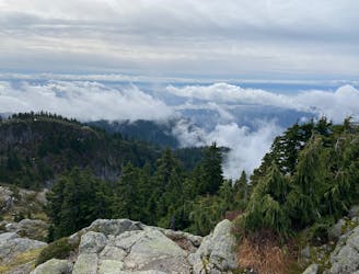
A scrambly hike to the summit of Mt. Seymour
Difficult Hiking

7 routes · Hiking · Trail Running

6 routes · Hiking

3 routes · Hiking