215 m away
Faux col

A wide open col leads to a classic off piste jaunt which leads back to the piste.
Difficult Freeride Skiing
- Distance
- 374 m
- Ascent
- 0 m
- Descent
- 231 m
A fun excursion a short way from the piste.
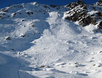
Freeride Skiing Severe

This is a popular freeride skiing route which is generally considered to be severe. It's remote, it features medium exposure (e2) and is typically done between December and April. From a low point of 2.3 km to the maximum altitude of 2.4 km, the route covers 184 m, 0 vertical metres of ascent and 138 vertical metres of descent. It's graded 3.2 and Labande grade 4.
Where the Charles-Bozon piste heads right at some small cliffs at c.2450 metres, branch off left and follow a broad ridge. Hold your height and veer right passing two prominent rocks to the entrance. Ski the wide open couloir returning back to the piste.
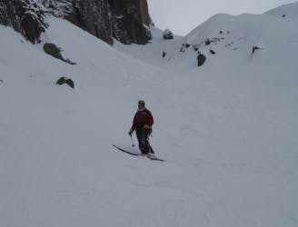
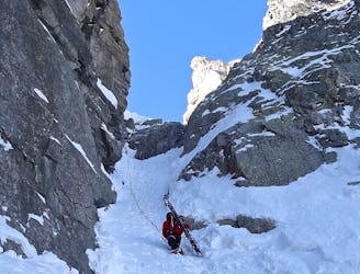
Severe
Steep skiing at 38-45 degrees. This requires very good technique and the risk of falling has serious consequences.

As well as the slope itself, there are some obstacles (such as rock outcrops) which could aggravate injury.
Away from help but easily accessed.
215 m away
A wide open col leads to a classic off piste jaunt which leads back to the piste.
Difficult Freeride Skiing
221 m away
“THE" classic freeride face at Brévent which offers numerous different routes of varying difficulty.
Severe Freeride Skiing
342 m away
Steep and serious skiing under the very impressive Brévent cliff face.
Severe Freeride Skiing
447 m away

A big couloir taking you back to the resort, well worth the extra work needed to hike.
Difficult Freeride Skiing
503 m away

Although shorter than the other Brevent couloirs the Allias offers a wider canvas pefect for opening up.
Severe Freeride Skiing
550 m away
Steep and serious terrain reached easily from the Brevent cable car, in a nutshell what Chamonix steep skiing is about.
Severe Freeride Skiing
722 m away

Good skiing awaits in this classic couloir which holds snow well until late in the day due to its westerly aspect
Severe Freeride Skiing
886 m away
One of the best descents off Brévent, with cold conditions needed.
Difficult Freeride Skiing
3.6 km away

A great extension from the Lachenal bowl that leads to the valley floor.
Difficult Freeride Skiing
4 km away

Long fall-line skiing straight off the lift.
Difficult Freeride Skiing

10 routes · Freeride Skiing · Ski Touring

10 routes · Freeride Skiing

10 routes · Freeride Skiing