1 km away
Goudissard

Low altitude tree skiing. Good in mid winter when the snow is thick all the way to the valley floor.
Moderate Freeride Skiing
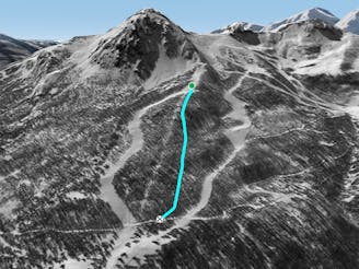
- Distance
- 1.3 km
- Ascent
- 0 m
- Descent
- 381 m
Easy tree line that goes through the mountain lodges
Freeride Skiing Easy

Turn right into the forest when you are on the blue trail "Les Vallons" just before it splits in half. Follow the river by staying about 50 meters above. Get back to the black trail "Luc Alphand" on your right when you cross the green trail "La Briance" The one who sees the most lodges (Chalet in french) wins !
Easy
Wide gentle slopes at around 20 degrees or less.

Exposure is limited to that of the slope itself. Getting hurt is still likely if the slope is steep and/or the snow is hard.
Close to help in case of emergency.
1 km away
Low altitude tree skiing. Good in mid winter when the snow is thick all the way to the valley floor.
Moderate Freeride Skiing
1.1 km away
Tree skiing at its best – well spaced larch forest spread over a huge area.
Difficult Freeride Skiing
1.6 km away

Not good all that often but when it’s on there’s almost nothing better.
Difficult Freeride Skiing
1.6 km away

A little bit of Canada comes to the French Alps. Exciting tree skiing best done on big powder days.
Difficult Freeride Skiing
1.7 km away

Almost a good run for first time off pisters but a tricky exit in particular makes it more of a challenge.
Moderate Freeride Skiing
1.8 km away

Big mountain ambiance north facing couloir followed by top quality tree skiing.
Difficult Freeride Skiing
1.8 km away

Steep, dynamic tree skiing for experts only.
Severe Freeride Skiing
1.8 km away

A highly visible couloir from the Chantemerle and Villeneuve ski areas. Good but poor ski to hike ratio.
Severe Freeride Skiing
1.8 km away

A glorious couloir and technically the easiest of the Prorel’s couloirs. To cap it off it transitions into some fantastic tree skiing.
Difficult Freeride Skiing
1.8 km away

A wide open line for less experienced off piste riders. Particularly good in spring snow conditions.
Difficult Freeride Skiing
10 routes · Freeride Skiing