5 m away
Prorel East Couloir

A glorious couloir and technically the easiest of the Prorel’s couloirs. To cap it off it transitions into some fantastic tree skiing.
Difficult Freeride Skiing
- Distance
- 3 km
- Ascent
- 16 m
- Descent
- 907 m
A highly visible couloir from the Chantemerle and Villeneuve ski areas. Good but poor ski to hike ratio.
Freeride Skiing Severe

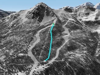
The 2566 metre summit of the Prorel dominates the Chantemerle and Briancon sectors and there are rideable routes on every aspect, ranging from the fairly straightforward to the highly exposed. The hike to the summit is up the west ridge and generally takes 20-30 minutes. If the climb is icy it is much more comfortable to use crampons as there are one or two places where you really don’t want to fall. The exact route depends on snow conditions and it is often necessary to move away from the ridge a bit and find a passage through the rocks on the first half of the climb. The northwest couloir splits the Prorel from top to bottom when seen from the Chantemerle and Villeneuve ski areas. It is almost asking to be skied! However, it’s fairly short and the climbing to riding ratio is not great. Still, it’s almost worth doing just so you and everyone else in the resort can admire your tracks for the rest of the day. From the summit the entrance is obvious but can get rocky. The wide open face below the couloir connects up with either the Saludes or the Eduits red runs.
Severe
Steep skiing at 38-45 degrees. This requires very good technique and the risk of falling has serious consequences.

As well as the slope itself, there are some obstacles (such as rock outcrops) which could aggravate injury.

Little chance of being seen or helped in case of an accident.
5 m away
A glorious couloir and technically the easiest of the Prorel’s couloirs. To cap it off it transitions into some fantastic tree skiing.
Difficult Freeride Skiing
7 m away

A wide open line for less experienced off piste riders. Particularly good in spring snow conditions.
Difficult Freeride Skiing
197 m away

Not good all that often but when it’s on there’s almost nothing better.
Difficult Freeride Skiing
473 m away

Big mountain ambiance north facing couloir followed by top quality tree skiing.
Difficult Freeride Skiing
524 m away

A popular and easily accessible descent - a wide open bowl followed by excellent trees.
Moderate Freeride Skiing
555 m away

A wide, gently undulating off piste slope suitable for less advanced off piste riders.
Moderate Freeride Skiing
692 m away

Steep SE facing lines that come into their own in perfect spring snow.
Difficult Freeride Skiing
790 m away

Steep and exposed, Rocher Carré can be used as an exciting start to a long tree run.
Severe Freeride Skiing
795 m away
Tree skiing at its best – well spaced larch forest spread over a huge area.
Difficult Freeride Skiing
1.7 km away

Big cliffs and steep, technical lines. Experts only in this complex and exposed area.
Severe Freeride Skiing
10 routes · Freeride Skiing