172 m away
Notre Dame des Neiges

Steep SE facing lines that come into their own in perfect spring snow.
Difficult Freeride Skiing
- Distance
- 1.2 km
- Ascent
- 1 m
- Descent
- 354 m
A popular and easily accessible descent - a wide open bowl followed by excellent trees.
Freeride Skiing Moderate

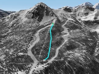
The Tour du Prorel is popular and easily accessible, requiring only a short (5 minute) hike from the top of the Croix de la Nore chairlift or the Prorel gondola. It feels like it should be a lot harder to find as you're quickly well away from any marked runs. After a wide open and fairly gentle top section that can get wind affected, you head into a forest that has a habit of all looking the same whichever way you go. The trick here is to keep left on your way down in order to get back to the bottom of the Aiguillette chairlift. If you get too low (all too easily done) you'll hit a snow covered road that you can hike up (left) to get back to the Aiguillette chair. Although the route finding can be confusing, this line has the advantage of not being too exposed, although there are a couple of steeper sections in the trees and you need to remain alert to the steeper slopes above and left on the top section. Recently, signs have been erected warning of potential fines for riding in this area. It is not the resort but the forestry service that polices this and it is unclear exactly which area is covered by the signs. One thing is sure - the route is as popular as ever with freeriders.
Moderate
Slopes become slightly steeper at around 25-30 degrees.

Exposure is limited to that of the slope itself. Getting hurt is still likely if the slope is steep and/or the snow is hard.

Little chance of being seen or helped in case of an accident.
172 m away
Steep SE facing lines that come into their own in perfect spring snow.
Difficult Freeride Skiing
344 m away

Steep and exposed, Rocher Carré can be used as an exciting start to a long tree run.
Severe Freeride Skiing
521 m away

A glorious couloir and technically the easiest of the Prorel’s couloirs. To cap it off it transitions into some fantastic tree skiing.
Difficult Freeride Skiing
522 m away

A wide open line for less experienced off piste riders. Particularly good in spring snow conditions.
Difficult Freeride Skiing
524 m away

A highly visible couloir from the Chantemerle and Villeneuve ski areas. Good but poor ski to hike ratio.
Severe Freeride Skiing
719 m away

Not good all that often but when it’s on there’s almost nothing better.
Difficult Freeride Skiing
815 m away

Big mountain ambiance north facing couloir followed by top quality tree skiing.
Difficult Freeride Skiing
840 m away

A wide, gently undulating off piste slope suitable for less advanced off piste riders.
Moderate Freeride Skiing
1.3 km away
Tree skiing at its best – well spaced larch forest spread over a huge area.
Difficult Freeride Skiing
2.1 km away

Big cliffs and steep, technical lines. Experts only in this complex and exposed area.
Severe Freeride Skiing
10 routes · Freeride Skiing