24 m away
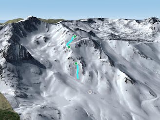
Pic Blanc North-west

Technical and challenging lines on the Pic Blanc North-west face.
Severe Freeride Skiing
- Distance
- 715 m
- Ascent
- 0 m
- Descent
- 270 m
Steep couloirs for experienced riders
Freeride Skiing Difficult

At the top of Pic Blanc chairlift turn right and hike up the western ridge of Pic Blanc (2639m). A wide but steep ridge will lead you to the summit. The ridge is also accessible by the Font Negre chairlift but you will have to hike back up the slope to get to Pic Blanc top station and access the ridge. Regarding safety, there can be cornices on the left of the ridge but the right side is clear and safe. The climb to Pic Blanc summit will take about 35 to 50 minutes depending on equipment and snow conditions. Crampons are not mandatory but are highly recommended in this climbing section due to ridge's exposure to and often icy conditions underfoot.Once at the top drop to the eastern ridge, the one which connects Pic Blanc to Pic d'Envalira. There is a little mountain pass just below and the southern couloir starts by dropping in to the right. It has an easy visual entrance. However heads up because the chute will turn right giving you no input once somebody is in. This line is easy, just follow the couloir and start riding to the right leaving Coma T-bar on your left. This is a very mellow area but close to the end go straight towards the Tbar because there is an artificial lake just at the bottom.
Difficult
Serious gradient of 30-38 degrees where a real risk of slipping exists.

As well as the slope itself, there are some obstacles (such as rock outcrops) which could aggravate injury.
Away from help but easily accessed.
24 m away
Technical and challenging lines on the Pic Blanc North-west face.
Severe Freeride Skiing
318 m away

Steep terrain for alpine off-piste experienced riders.
Severe Freeride Skiing
321 m away

Extreme narrow steep couloir for advanced experienced riders
Difficult Freeride Skiing
330 m away

An open terrain freeride area
Moderate Freeride Skiing
509 m away

Popular off piste with terrain with easy access.
Severe Freeride Skiing
561 m away
A steep line through rocky terrain for experienced riders
Difficult Freeride Skiing
648 m away

Short, technical and steep couloirs
Severe Freeride Skiing
980 m away

Wide steep riding from Coll Blanc
Moderate Freeride Skiing
1.3 km away

Easy access freeride area for intermediate riders
Moderate Freeride Skiing
1.9 km away

Classic freeride lines out of the resort boundaries
Moderate Freeride Skiing
22 routes · Freeride Skiing