4 m away
Pic Negre d'Envalira N

Steep terrain for alpine off-piste experienced riders.
Severe Freeride Skiing
- Distance
- 676 m
- Ascent
- 1 m
- Descent
- 283 m

Extreme narrow steep couloir for advanced experienced riders
Freeride Skiing Difficult

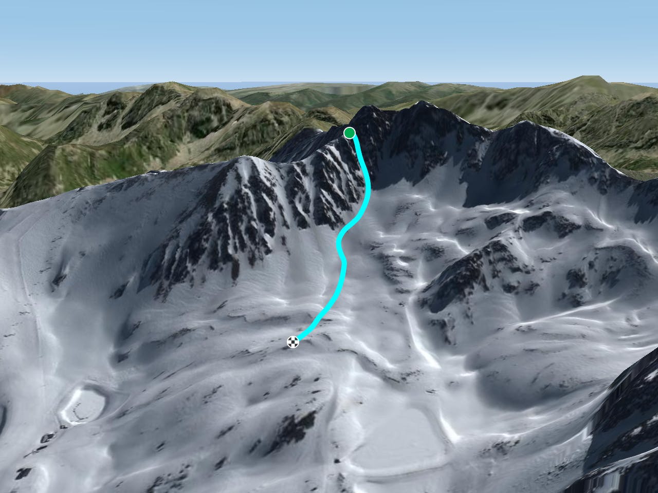
At the top of Pic Blanc chairlift turn right and hike up the western ridge of Pic Blanc (2639m). A wide but steep ridge will lead you to the summit. The ridge is also accessible by the Font Negre chairlift but you will have to hike back up the slope to get to Pic Blanc top station and access the ridge. Regarding safety, there can be cornices on the left of the ridge but the right side is clear and safe. The climb to Pic Blanc summit will take about 35 to 50 minutes depending on equipment and snow conditions. Crampons are not mandatory but are highly recommended in this climbing section due to ridge's exposure to and often icy conditions underfoot. Once at the top you can ride down the eastern ridge to the mountain pass and face up the last challenge; hiking and climbing up the western ridge of Pic Negre d'Envalira, a sharp ridge but wide enough to walk on which gives you access to the steep couloir hidden from the view. Crampons and ice axes are highly recommended, and even ropes for those not confident climbing. Rope length will depend on how many party members there are. There are two steep sections where climbing of ice and snow is required but complete ice climbing equipment shouldn't be necessary. There is a rocky flat area to stop just before the couloir and the mountain wall ahead. The couloir is pretty obvious with a very steep section at the beginning. There are other couloirs with easier terrain before this one, make sure you had a visual before and the conditions are good to ride. Visuals can be made from the top of Coma T-bar. Scoping the line is recommended. Once you've ridden the couloir and out of it ride to the right, avoiding a very rocky area and ride towards the Coma T-Bar top station, merging into the piste there. A lake is little bit further down on your right.
Difficult
Serious gradient of 30-38 degrees where a real risk of slipping exists.
4 m away

Steep terrain for alpine off-piste experienced riders.
Severe Freeride Skiing
300 m away

Technical and challenging lines on the Pic Blanc North-west face.
Severe Freeride Skiing
321 m away

Steep couloirs for experienced riders
Difficult Freeride Skiing
586 m away

An open terrain freeride area
Moderate Freeride Skiing
718 m away

Popular off piste with terrain with easy access.
Severe Freeride Skiing
788 m away

A steep line through rocky terrain for experienced riders
Difficult Freeride Skiing
893 m away

Short, technical and steep couloirs
Severe Freeride Skiing
1.3 km away

Wide steep riding from Coll Blanc
Moderate Freeride Skiing
1.5 km away

Easy access freeride area for intermediate riders
Moderate Freeride Skiing
2.2 km away

Classic freeride lines out of the resort boundaries
Moderate Freeride Skiing

22 routes · Freeride Skiing