346 m away
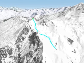
Cairn Couloir

Fantastic but serious big mountain line on a majestic, wild north face
Severe Freeride Skiing
- Distance
- 4.4 km
- Ascent
- 12 m
- Descent
- 1.6 km
Long Bootpack with lots of drop-ins along the ridge.
Freeride Skiing Severe

This is a popular freeride skiing route which is generally considered to be severe. It's remote, it features medium exposure (e2) and is typically done between January and May. From a low point of 3 km to the maximum altitude of 3.4 km, the route covers 989 m, 369 vertical metres of ascent and 9 vertical metres of descent. You'll need ice axe and crampons to complete it safely.
N/A
Severe
Steep skiing at 38-45 degrees. This requires very good technique and the risk of falling has serious consequences.

As well as the slope itself, there are some obstacles (such as rock outcrops) which could aggravate injury.
Away from help but easily accessed.
346 m away
Fantastic but serious big mountain line on a majestic, wild north face
Severe Freeride Skiing
403 m away

The easiest of the classics on the true north face.
Severe Freeride Skiing
474 m away

A classic route down the north face, one of the less risky routes
Moderate Freeride Skiing
645 m away

A beautiful, varied line down wild open slopes
Difficult Freeride Skiing
1.9 km away

An equally fine companion route to the Couloir de Pramain
Difficult Freeride Skiing
2.9 km away

A fairly short, but enjoyable series of bowls and funnels leading through the steep ground on the east face of the Roche de Mio
Difficult Freeride Skiing
3 km away

A magnificent wild open valley with a tricky exit, ending in an isolated village
Difficult Freeride Skiing
6.2 km away
A hike to some great views followed by a flowing descent down a west facing bowl
Moderate Freeride Skiing
6.2 km away
A wild, steep line that needs stable snow conditions and finishes outside the lift served area
Severe Freeride Skiing
6.3 km away

A steep rarely skied line from the top of the Aiguille Grive
Severe Freeride Skiing
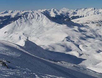
25 routes · Freeride Skiing
6 routes · Freeride Skiing

15 routes · Freeride Skiing · Ski Touring