3.3 km away
Creux Bozon

An equally fine companion route to the Couloir de Pramain
Difficult Freeride Skiing
- Distance
- 2.2 km
- Ascent
- 0 m
- Descent
- 758 m
Easy but not that safe...
Freeride Skiing Moderate

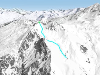
The climb up to the summit of the Saint Jacques follows its eastern ridge from the pass separating it from the Tête de l'Arpette. A little chapel, often buried under the snow, shares the Summit with several VHF relays. Skiing and snowboarding are forbidden by municipal decree on the western and southwestern faces of the Saint Jacques (zones covered with avalanche protections), but you can ride down the northwestern triangle and the northern slopes when the snow-pack is stable. They are often laden with unstable snow. The least dangerous route follows the right side of the northwest slope and then dodges between the trees and, at the bottom of the slope, crosses through a wide gap. Be prudent in the upper section of the forest where a wide, treeless couloir is not the work of lumberjacks...
On the north side of the Saint-Jacques, several couloirs and slopes open onto a clearing that is also the work of previous avalanches! This area is great to ride in but should be avoided when the snow-pack is not perfectly stabilized. These two routes meet up at the cross-country trail just above the Frasses clearing where a forest road starts near a small group of chalets on the right and traverses the mountainside to the hamlet of Plangagnant. From there you must cross the main road to get the chairlift La Roche that will take you back above Plagne center.
Moderate
Slopes become slightly steeper at around 25-30 degrees.

As well as the slope itself, there are some obstacles (such as rock outcrops) which could aggravate injury.

Little chance of being seen or helped in case of an accident.
3.3 km away
An equally fine companion route to the Couloir de Pramain
Difficult Freeride Skiing
3.5 km away

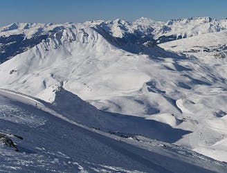
A fairly short, but enjoyable series of bowls and funnels leading through the steep ground on the east face of the Roche de Mio
Difficult Freeride Skiing
3.6 km away

A magnificent wild open valley with a tricky exit, ending in an isolated village
Difficult Freeride Skiing
4.6 km away

A beautiful, varied line down wild open slopes
Difficult Freeride Skiing
4.7 km away

A classic route down the north face, one of the less risky routes
Moderate Freeride Skiing
4.8 km away

The easiest of the classics on the true north face.
Severe Freeride Skiing
5.5 km away

Fantastic but serious big mountain line on a majestic, wild north face
Severe Freeride Skiing
7.3 km away
A hike to some great views followed by a flowing descent down a west facing bowl
Moderate Freeride Skiing
7.3 km away
A wild, steep line that needs stable snow conditions and finishes outside the lift served area
Severe Freeride Skiing
7.4 km away

A steep rarely skied line from the top of the Aiguille Grive
Severe Freeride Skiing
25 routes · Freeride Skiing
6 routes · Freeride Skiing

15 routes · Freeride Skiing · Ski Touring