339 m away
Fornet Trees

Great tree skiing - good for bad visibility/weather days
Difficult Freeride Skiing
- Distance
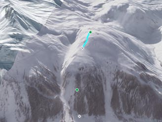
- 1.3 km
- Ascent
- 11 m
- Descent
- 397 m
Short, steep, easy-access tree lines
Freeride Skiing Difficult

Between the Fornet black and Mangard blue pistes are a series of fun and challenging gullies through the forest. At the end of the first fall-line pitch the piste turns sharply to the right and follows what, in summer, is a road. At various points along this road obvious gullies drop down into the forest, some narrower and more technical than others. Tread carefully on your way down as some have sudden and somewhat unexpected drops! Whichever route you take you'll rejoin the Mangard piste to the bottom of the Fornet cable car. Great quick laps are to be had here among the trees on a storm day.
Difficult
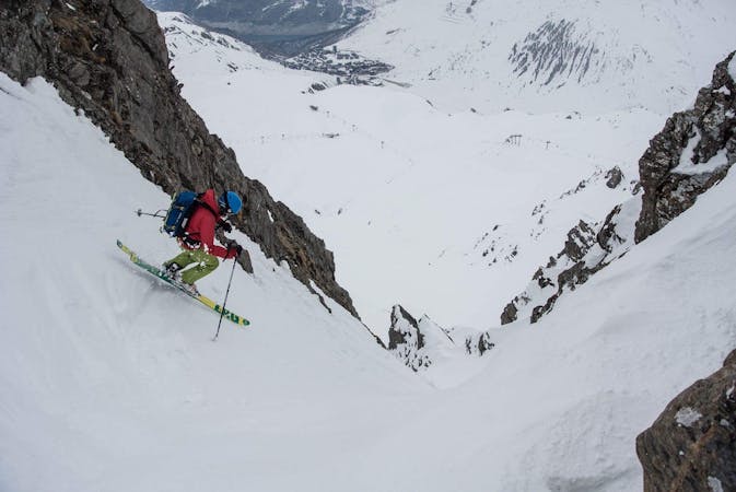
Serious gradient of 30-38 degrees where a real risk of slipping exists.

As well as the slope itself, there are some obstacles (such as rock outcrops) which could aggravate injury.
Away from help but easily accessed.
339 m away
Great tree skiing - good for bad visibility/weather days
Difficult Freeride Skiing
1.1 km away

Great short descent through open terrain and short forrest.
Difficult Freeride Skiing
1.2 km away

Wide open skiing with a few fun variations.
Difficult Freeride Skiing
1.3 km away

An easily-accessed bowl to lap straight after snowfall.
Difficult Freeride Skiing
1.7 km away

Easy access off piste run on a large north facing slope often offering fantastic cold snow.
Difficult Freeride Skiing
1.8 km away

More technical variant of Grand Vallon
Difficult Freeride Skiing
1.8 km away

A long ski descent away from the lifts with a lot of space for exploration.
Difficult Freeride Skiing
1.9 km away

Easy access off piste run on a large north facing slope often with fantastic cold snow
Difficult Freeride Skiing
2 km away

A popular, easy to access classic couloir - you'll need to get up early to get first tracks here.
Difficult Freeride Skiing
2.3 km away
This alternative line to the Lavancher couloir provides some steep tree skiing but can be dangerous.
Severe Freeride Skiing
70 routes · Freeride Skiing
6 routes · Freeride Skiing