1 km away
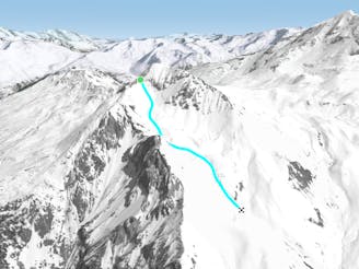
Cairn Couloir

Fantastic but serious big mountain line on a majestic, wild north face
Severe Freeride Skiing
- Distance
- 4.4 km
- Ascent
- 12 m
- Descent
- 1.6 km
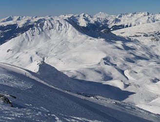
THE off-piste in La Plagne
Freeride Skiing Difficult

This magnificent descent is the reference in off-piste skiing in La Plagne. It covers extremely varied terrain and faces the most beautiful summits in La Vanoise. The Cul du Nant Glacier reveals itself just over the ridge that separates it from the Chiauppe Glacier. You access that ridge by a quick walk straight out the arrival of the Glacier chairlift.
The glacier is quite wide with few crevasses (mostly early in the season), bur it's preferable to stay on its right side, as it is also better to stay the right side of the huge undulating terrain that follow the glacier. Under the Refuge de Plaisance, the wide valley narrows into a first constriction where you must cross over onto the left bank (warning : the river hides dangerous potholes under a layer of snow). The slope then widens again into an avalanche deposit zone. Do not follow the river that flows into a waterfall in the Laisonney valley, but cross to the left and follow a summer trail that can be tricky. Finally, a last slope with uncertain snow conditions (generally a lack of snow) leads to the Champagny le Haut cross-country trail. Skate along (while yielding to the Nordic skiers) for 3km until you reach Champagny le Haut. Then a bus will take you to Chamagny-en-Vanoise and the Champagny gondola back to the resort groomed slopes :)
Difficult
Serious gradient of 30-38 degrees where a real risk of slipping exists.

In case of a fall, death is highly likely.
Little chance of being seen or helped in case of an accident.
1 km away
Fantastic but serious big mountain line on a majestic, wild north face
Severe Freeride Skiing
1.7 km away

The easiest of the classics on the true north face.
Severe Freeride Skiing
1.8 km away

A classic route down the north face, one of the less risky routes
Moderate Freeride Skiing
2 km away

A beautiful, varied line down wild open slopes
Difficult Freeride Skiing
3.2 km away

An equally fine companion route to the Couloir de Pramain
Difficult Freeride Skiing
3.6 km away

A fairly short, but enjoyable series of bowls and funnels leading through the steep ground on the east face of the Roche de Mio
Difficult Freeride Skiing
3.6 km away

A magnificent wild open valley with a tricky exit, ending in an isolated village
Difficult Freeride Skiing
7.2 km away
A hike to some great views followed by a flowing descent down a west facing bowl
Moderate Freeride Skiing
7.2 km away
A wild, steep line that needs stable snow conditions and finishes outside the lift served area
Severe Freeride Skiing
7.2 km away

A steep rarely skied line from the top of the Aiguille Grive
Severe Freeride Skiing
25 routes · Freeride Skiing
6 routes · Freeride Skiing

15 routes · Freeride Skiing · Ski Touring