293 m away
BettaForca Skiers Right

A great freeride warm-up run, fast and fun - just follow your nose.
Moderate Freeride Skiing
- Distance
- 1.5 km
- Ascent
- 0 m
- Descent
- 371 m
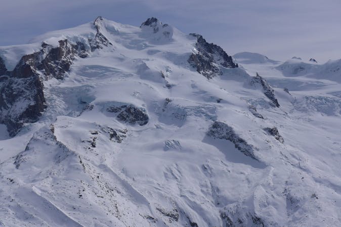
One of the best itineraries of this area: wide slopes and a wild environment.
Freeride Skiing Difficult

The Bettolina is the classic route off this side of the Monte Rosa, although it is difficult to find without tracks. After a big snowfall be careful as some zones are prone to avalanches (particularly the right side after the couloir). It is an ideal route for snowboarders due to easy access and the traverse through the forest is almost always tracked out.
From the top station of the Bettaforca chairlift, descend to the left and follow the beaten track for a few meters. After descending down on the piste head straight off-piste and enter a wide valley. Follow the valley to the entrance of a short couloir that leads into a large long slope. Ski down and enter another gully which steepens progressively and leads you to the forest below. Traverse to the right without losing any height just below a rocky barrier and into the forest. Follow the track until you rejoin the bottom piste to return back to Stafal.
You can access the lower part of this run as a ski tour by following the ski tour to the Quintino Sella refuge, then dropping off to your right part way. This is once you have got to the ridge beyond the large peak above you on the left as you skin up.
Difficult
Serious gradient of 30-38 degrees where a real risk of slipping exists.

As well as the slope itself, there are some obstacles (such as rock outcrops) which could aggravate injury.

In the high mountains or remote conditions, all individuals must be completely autonomous in every situation.
293 m away
A great freeride warm-up run, fast and fun - just follow your nose.
Moderate Freeride Skiing
309 m away

A great freeride warm-up run, fast and fun with a quick traverse at the beginning.
Moderate Freeride Skiing
486 m away

Great variant of the Bettolina classic, requires a short walk.
Moderate Freeride Skiing
1.3 km away

A steep couloir
Difficult Freeride Skiing
2 km away

Short run near the cable car
Difficult Freeride Skiing
2 km away

Have fun in this natural pipe!
Moderate Freeride Skiing
2.1 km away

Short run under the cable car
Difficult Freeride Skiing
2.2 km away

Short run near the cable car.
Difficult Freeride Skiing
2.5 km away

Good north exposed woods
Moderate Freeride Skiing
2.7 km away

A nice tour through a beautiful village
Easy Freeride Skiing
12 routes · Freeride Skiing