1.2 km away
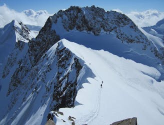
Monte Rosa Haute Route: Margherita Hut and the Grenz Glacier
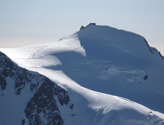
Day 4: Margherita Hut and the Grenz Glacier, beginning at Gnifettti Hut and ending at Neue Monte Rosa Hut
Difficult Ski Touring
- Distance
- 12 km
- Ascent
- 1 km
- Descent
- 1.8 km
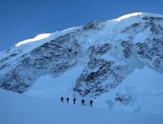
The Lost Valley is a superb descent onto the Lys Glacier: high mountain and glacier travel experience necessary.
Ski Touring Severe

The Lost Valley takes its name from an ancient Walser legend of a valley hidden amongst the icy flanks of the Monte Rosa. Despite the wide slopes and the often great snow conditions, this is a high altitude route with a difficult mountaineering approach and a descent through the glacier between seracs and crevasses. You must have a good knowledge of glacier travel and mountaineering techniques.
From the top station at Punta Indren, traverse across the left side of the small Indren glacier without loosing height until you reach an extensive rock band (the line of the traverse is usually safe but beware of small crevasses covered by snow). Keep traversing on the diagonal at the same height (this area is especially prone to slabs forming from high winds). Continue past a small valley descending from the Mantova hut.
From here, climb up to the obvious col situated at the right of a large boulder via the right ridge extending down from the summit of the Altaluce (north ridge, approximately 20 minutes climb). The entrance to the couloir is equipped with one fixed bolt on the top, and two fixed bolts a further 40m down. It is difficult to ski down here as it is very narrow and steep (45°) and the snow cover is often poor. You will need to make two abseils, each of them 40m long. So if you are without a guide you will need to carry 80m of rope.
At the bottom of the couloir you will land on the Lys glacier. The first section on the left, near the rock barrier, is not glaciated. Descend to the south until you reach an obvious change in the angle of the slope, at this point bear left. After another change of angle in the slope with a cliff below you, traverse to the right (northwest) to find a narrow passage through the seracs and rocks.
Continue to ski down the side of the glacier to a flat area before the end of the valley. Be careful not to ski straight down any further because there is a huge cliff. Turn right (north) to find the passage that leads to the end of the glacier. Move onto the other face, following the valley beside the moraine. The next section is in a wooded area, ski on the right side until the long flat section. You will reach a block (municipal water system). From here take the Salza itinerary to Stafal.
Severe
Steep skiing at 38-45 degrees. This requires very good technique and the risk of falling has serious consequences.

As well as the slope itself, there are some obstacles (such as rock outcrops) which could aggravate injury.

In the high mountains or remote conditions, all individuals must be completely autonomous in every situation.
1.2 km away
Day 4: Margherita Hut and the Grenz Glacier, beginning at Gnifettti Hut and ending at Neue Monte Rosa Hut
Difficult Ski Touring
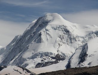
4.4 km away
Day 3: Traverse of Passo del Naso of Lyskamm and summit of Pyramid Vincent, beginning at Rifugio Quintino Sella and ending at Capanna Gnifetti.
Severe Ski Touring
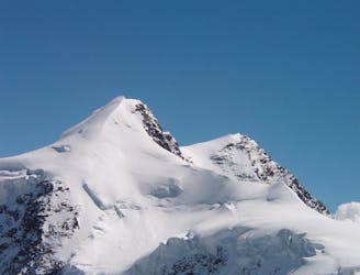
4.4 km away
Venture up Switzerland’s famously treacherous Liskamm 4000er, affectionately nicknamed the “people eater”.
Severe Ski Touring
5 km away

One of the most aesthetic couloirs on this side of the mountain
Severe Ski Touring
7.1 km away
Day 2: Traverse of Castor, optional extra summit of Pollux, beginning at Rifugio Guide d'Ayas and ending at Rifugio Quintino Sella
Severe Ski Touring
7.9 km away
Day 5: A huge skin to a high col and optional climb up Europe's 2nd highest peak
Severe Ski Touring

5 routes · Freeride Skiing · Ski Touring

5 routes · Ski Touring

16 routes · Ski Touring