6.5 km away
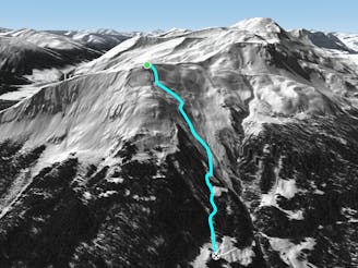
Gotschnagrat E Face

Extreme freeride area for experienced riders
Extreme Freeride Skiing
- Distance
- 951 m
- Ascent
- 0 m
- Descent
- 499 m
Steep coulouirs and slopes on the W side of Bärnet
Freeride Skiing Severe

From Schaffürggli T-bar ride east and hike the west ridge of Bärnet (2378m). It is a 1,5 hours hike through the ridge till the summit. It is a wide ridge without to many complications other than snow depth and possible cornices all the way along it. You don't have to walk to far to start getting access to steep lines on the W side of the ridge. The ride from the peak till slope nº 4 has a lot of lines and variety for experienced riders. It is a rocky area with a very steep top to middle section. Pick up your line according your riding level, visuals can be made from the T-bar and slope nº4.
Severe
Steep skiing at 38-45 degrees. This requires very good technique and the risk of falling has serious consequences.

In case of a fall, death is highly likely.
Little chance of being seen or helped in case of an accident.
6.5 km away
Extreme freeride area for experienced riders
Extreme Freeride Skiing
6.5 km away
Long freeride line from alpine to forest terrain for advanced skiers
Severe Freeride Skiing
6.6 km away

Wide steep slope on the Gotschnagrat NW face.
Severe Freeride Skiing
6.7 km away

Short steep sections from Gotschnagrat east ridge
Difficult Freeride Skiing
7.9 km away

Wide freeride slope from Seetäli to Obersäas valley
Difficult Freeride Skiing
8 km away

Easy acces freeride area for intermediate riders
Moderate Freeride Skiing
8.1 km away

Steep lines for experienced and extreme riders
Extreme Freeride Skiing
8.5 km away

Great steep SE slope from the top of Parsennfurgga with easy access
Severe Freeride Skiing
8.7 km away

Freeride below Parsennfurgga (2443m) with easy acces
Moderate Freeride Skiing
9.4 km away

From Totalphorn (2532m) to Gruobenalp ski out (slope nº16)
Difficult Freeride Skiing
18 routes · Freeride Skiing