196 m away
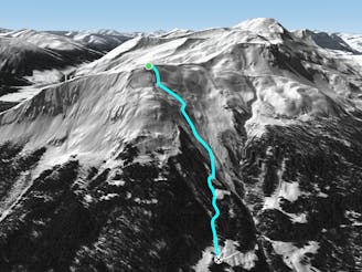
NW Seetali

Steep lines for experienced and extreme riders
Extreme Freeride Skiing
- Distance
- 944 m
- Ascent
- 0 m
- Descent
- 325 m
Wide freeride slope from Seetäli to Obersäas valley
Freeride Skiing Difficult

From the top of Seetälli Tbar turn right and go straight to the first mountain pass on your left. Usually there is a out of boundaries sign there and you will start a little traverse around 50 meters, after that just hike up the wide ridge about 10 minutes. Once on the higher pass and on the wide ridge you can see Obersäss valley the red slope (nº24) and probably you should see Schiferbahn middle as well aon your lower right. This starts with a steep wide slope followed by a fun rolling area. Watch out on or after windy days because of its face orientation usually gets wind affected especially at the top where the start point is. Despite that there are lots of options at the beginning, riding down the rolling area and riding slightly to the right. After that the terrain gets flatter, slope 21 should be visible on your far left, and you can keep riding down where a wide creek will open up. Its all ridable and it finishes where pistes 21 and 47 merge.
Difficult
Serious gradient of 30-38 degrees where a real risk of slipping exists.

As well as the slope itself, there are some obstacles (such as rock outcrops) which could aggravate injury.
Away from help but easily accessed.
196 m away
Steep lines for experienced and extreme riders
Extreme Freeride Skiing
406 m away

Easy acces freeride area for intermediate riders
Moderate Freeride Skiing
650 m away

Great steep SE slope from the top of Parsennfurgga with easy access
Severe Freeride Skiing
912 m away

Freeride below Parsennfurgga (2443m) with easy acces
Moderate Freeride Skiing
2.1 km away

From Totalphorn (2532m) to Gruobenalp ski out (slope nº16)
Difficult Freeride Skiing
2.1 km away

Fun rocky slope on the Totalphorn north face
Severe Freeride Skiing
2.1 km away

Ridge riding for experienced skiers
Difficult Freeride Skiing
2.3 km away
Long freeride line from alpine to forest terrain for advanced skiers
Severe Freeride Skiing
2.4 km away

Extreme freeride area for experienced riders
Extreme Freeride Skiing
2.5 km away

Wide steep slope on the Gotschnagrat NW face.
Severe Freeride Skiing
18 routes · Freeride Skiing