405 m away
Les Hauts Forts: South Face Second Couloir

This steep couloir is a slightly easier descent than its neighbour.
Severe Freeride Skiing
- Distance
- 4.1 km
- Ascent
- 41 m
- Descent
- 1.3 km
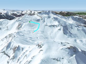
Bag a summit and enjoy an enormous off-piste face with a variety of lines in close proximity to the resort.
Also in Haute-Savoie, France
Freeride Skiing Severe

Follow the itinerary for the Arare couloir, but once on the summit of the Hauts Forts descend via the western ridge that gradually tapers down towards the top of the Nant d'Ankerne (Encornette) couloir. Pass by the entrance of the couloir and ascend the steep slope to the west summit (2,359m). From this point you can ski as far along the ridge to the west as you like before dropping into the face and enjoying an excellent off-piste pitch with a multitude of lines all the way down to the forest. There are often many tracks in the lower half of the face that are easy to follow through the woods to reach the piste down to Prodains.
Severe
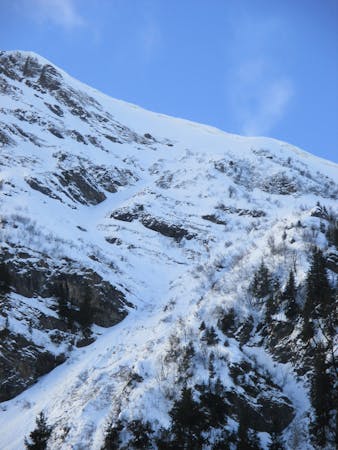
Steep skiing at 38-45 degrees. This requires very good technique and the risk of falling has serious consequences.

As well as the slope itself, there are some obstacles (such as rock outcrops) which could aggravate injury.

Little chance of being seen or helped in case of an accident.
405 m away
This steep couloir is a slightly easier descent than its neighbour.
Severe Freeride Skiing
1.8 km away

A legendary couloir known to be popular with the local ski patrol, for expert skiers only.
Severe Freeride Skiing
1.9 km away

Lift accessed area classic with a free bus ride back to Morzine.
Moderate Freeride Skiing
1.9 km away

Magnificent and very steep couloir on the north side of Ressachaux.
Extreme Freeride Skiing
2.8 km away

A variety of lines for experienced skiers with airy, exposed ascent.
Difficult Freeride Skiing
2.8 km away

Classic off-piste route for experienced skiers with short but exposed hike.
Difficult Freeride Skiing
3 km away

A ice long line giving some steepness and some tree skiing which requires good skills.
Severe Freeride Skiing
3 km away

Challenging line for experienced backcountry skiers with airy and exposed ascent.
Severe Freeride Skiing
3 km away
Great pitch that looks intimidating from above but offers a huge variety of lines that you can ride again and again.
Difficult Freeride Skiing
3 km away

Easily accessed line but really steep.
Extreme Freeride Skiing

18 routes · Freeride Skiing
9 routes · Freeride Skiing · Ski Touring