4.7 km away
Dent d'Oche
You can't call yourself a local until you've climbed this peak.
Extreme Hiking
- Distance
- 7.5 km
- Ascent
- 1 km
- Descent
- 1 km
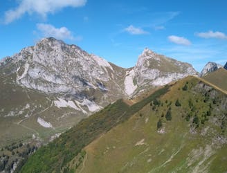
Dent du Vélan et Cornettes de Bise
Also in Haute-Savoie, France
Hiking Difficult

This is a popular hiking route which is generally considered to be difficult. It's not remote, it features medium exposure and is typically done between May and September. From a low point of 1.5 km to the maximum altitude of 2.4 km, the route covers 15 km, 1414 vertical metres of ascent and 1437 vertical metres of descent.
Dent du Vélan et Cornettes de Bise, randonnée en boucle. Le sentier du versant sud est peu balisé.
Difficult
Hiking trails where obstacles such as rocks or roots are prevalent. Some obstacles can require care to step over or around. At times, the trail can be worn and eroded. The grade of the trail is generally quite steep, and can often lead to strenuous hiking.

The trail contains some obstacles such as outcroppings and rock which could cause injury.

Close to help in case of emergency.
4.7 km away
You can't call yourself a local until you've climbed this peak.
Extreme Hiking
9.8 km away
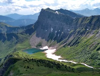
An accessible summit and lake combination.
Difficult Hiking