189 m away
Mustang Gate Route

The traverse route to take after you enter through the backcountry gate
Moderate Freeride Skiing
- Distance
- 364 m
- Ascent
- 14 m
- Descent
- 42 m
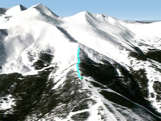
Ridge off of the top of Mustang
Freeride Skiing Difficult

This is a popular freeride skiing route which is generally considered to be difficult. It's not remote, it features medium exposure (e2) and is typically done in an unknown time of year. From a low point of 3.4 km to the maximum altitude of 3.5 km, the route covers 186 m, 0 vertical metres of ascent and 61 vertical metres of descent.
This is another option off the top of the Mustang. It is a tree run that is steep and tight. It is another good option that is often less skied.
Difficult
Serious gradient of 30-38 degrees where a real risk of slipping exists.

As well as the slope itself, there are some obstacles (such as rock outcrops) which could aggravate injury.

Close to help in case of emergency.
189 m away
The traverse route to take after you enter through the backcountry gate
Moderate Freeride Skiing
206 m away

Nice open bowl near Mustang.
Extreme Freeride Skiing
239 m away

Tight banked tree run off Corsair
Moderate Freeride Skiing
315 m away
Top of Falcon Chair Hike
Moderate Freeride Skiing
350 m away

Secret Little Tree run at the bottom of the Mustang Bowl
Moderate Freeride Skiing
477 m away

Another chute off the ballroom hike
Difficult Freeride Skiing
510 m away

Another way to ski the burn
Difficult Freeride Skiing
527 m away

Lower angle powder fields that end with a short steep bowl
Moderate Freeride Skiing
605 m away

Short south facing bowl
Difficult Freeride Skiing
610 m away

Another option off the bootpack of ballroom
Difficult Freeride Skiing