5 m away
Ballroom 3

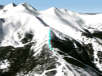
Another option off the bootpack of ballroom
Difficult Freeride Skiing
- Distance
- 504 m
- Ascent
- 0 m
- Descent
- 183 m
Short south facing bowl
Freeride Skiing Difficult

This is a popular freeride skiing route which is generally considered to be difficult. It's remote, it features medium exposure (e2) and is typically done in an unknown time of year. From a low point of 3.5 km to the maximum altitude of 3.6 km, the route covers 193 m, 0 vertical metres of ascent and 89 vertical metres of descent.
Rarely skis well and is highly wind affected, please use caution when skiing this chute, it is not controlled. It will put you into a drainage that will require you to bushwack out of.
Difficult
Serious gradient of 30-38 degrees where a real risk of slipping exists.

As well as the slope itself, there are some obstacles (such as rock outcrops) which could aggravate injury.
Away from help but easily accessed.
5 m away
Another option off the bootpack of ballroom
Difficult Freeride Skiing
73 m away

Another ballroom option off the bootpack hike
Difficult Freeride Skiing
89 m away

Short South Facing Bowl
Difficult Freeride Skiing
128 m away

Another chute off the ballroom hike
Difficult Freeride Skiing
155 m away

Bushwacking traverse out
Easy Freeride Skiing
257 m away

A fun and wide open tree run that gets steeper and tighter from top to bottom.
Difficult Freeride Skiing
298 m away
Top of Falcon Chair Hike
Moderate Freeride Skiing
345 m away

A fun short tree run that gets steeper and tighter from top to bottom.
Difficult Freeride Skiing
539 m away

Tight banked tree run off Corsair
Moderate Freeride Skiing
605 m away

Ridge off of the top of Mustang
Difficult Freeride Skiing