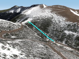
1.3 km away
The 40 Gate

A steep forest of trees that take you out of bounds from Parry's Peak on Parsenn Bowl to Highway 40
Difficult Freeride Skiing
- Distance
- 674 m
- Ascent
- 0 m
- Descent
- 236 m
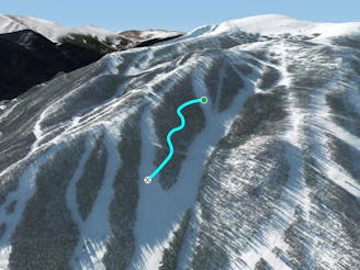
A slanted but fun trail directly under Panoramic Lift
Freeride Skiing Moderate

Pano Lift Line is not on the map, but it is a heavily used intermediate-level trail that is usually ungroomed. The trail is slanted, but you can duck in and out of the trees, and it’s fun – especially on a powder day with all the chairlift audience hooting and hollering (the mutual celebration can get kind of loud on a big pow day). At the top, take a left getting off the lift (south, towards Parry’s Peek Trail) and go under the Panoramic Lift when it gets to treeline. It's pretty flat at the beginning, where many people dive down into the trees rather than stay under the lift. Follow under the lift to Edelweiss and back to the Panoramic/Sunnyside Lift corrals or dive into the trees at any location into Lower Johnstone Junction or Willett’s Way. Anyway is the right way on a powder day at Parsenn Bowl. The higher you go ... the better the snow!
Moderate
Slopes become slightly steeper at around 25-30 degrees.

Exposure is limited to that of the slope itself. Getting hurt is still likely if the slope is steep and/or the snow is hard.
Close to help in case of emergency.
1.3 km away
A steep forest of trees that take you out of bounds from Parry's Peak on Parsenn Bowl to Highway 40
Difficult Freeride Skiing
1.8 km away

A steep tightly gladed area with small cliffs and unexpected obstacles
Severe Freeride Skiing
2.3 km away
A large section of steep woods between Phantom Bridge and Railbender trails
Difficult Freeride Skiing
5 km away

Some south facing glades
Difficult Freeride Skiing
5 km away

Mellow tree skiing.
Moderate Freeride Skiing
5.3 km away

No-hike-necessary tree skiing on Hell's Half Acre.
Moderate Freeride Skiing
5.4 km away

No-hike-necessary tree skiing thanks to a shuttle on Berthoud Pass.
Moderate Freeride Skiing
5.5 km away
A low-angle cut through the trees
Moderate Freeride Skiing
15 routes · Freeride Skiing · Ski Touring

77 routes · Freeride Skiing · Ski Touring