136 m away
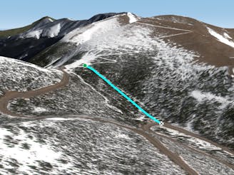
Wyskis

Mellow tree skiing.
Moderate Freeride Skiing
- Distance
- 589 m
- Ascent
- 0 m
- Descent
- 130 m
Some south facing glades
Freeride Skiing Difficult

This is a popular freeride skiing route which is generally considered to be difficult. It's remote, it features unknown exposure and is typically done between December and April. From a low point of 3.4 km to the maximum altitude of 3.6 km, the route covers 3.2 km, 406 vertical metres of ascent and 608 vertical metres of descent.
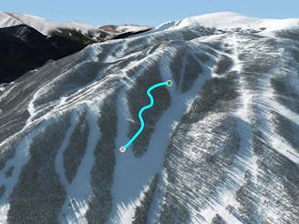
Heading south from the Upper Weather Station takes you into the Pumphouse area, which offers about 650 feet of tree skiing. The top of Pumphouse is significantly flatter than the bottom. Since it has a southern aspect, Pumphouse is much better when there is new snow.
Difficult
Serious gradient of 30-38 degrees where a real risk of slipping exists.

Away from help but easily accessed.
136 m away
Mellow tree skiing.
Moderate Freeride Skiing
768 m away

No-hike-necessary tree skiing thanks to a shuttle on Berthoud Pass.
Moderate Freeride Skiing
780 m away

No-hike-necessary tree skiing on Hell's Half Acre.
Moderate Freeride Skiing
926 m away
A low-angle cut through the trees
Moderate Freeride Skiing
5 km away

A slanted but fun trail directly under Panoramic Lift
Moderate Freeride Skiing
5.4 km away

A steep forest of trees that take you out of bounds from Parry's Peak on Parsenn Bowl to Highway 40
Difficult Freeride Skiing
6.4 km away

A steep tightly gladed area with small cliffs and unexpected obstacles
Severe Freeride Skiing
7.1 km away
A large section of steep woods between Phantom Bridge and Railbender trails
Difficult Freeride Skiing
15 routes · Freeride Skiing · Ski Touring

77 routes · Freeride Skiing · Ski Touring