136 m away
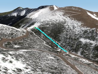
Pumphouse

Some south facing glades
Difficult Freeride Skiing
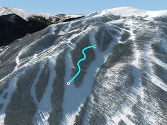
- Distance
- 3.2 km
- Ascent
- 406 m
- Descent
- 608 m
Mellow tree skiing.
Freeride Skiing Moderate

This is a popular freeride skiing route which is generally considered to be moderate. It's not remote, it features medium exposure (e2) and is typically done between November and April. From a low point of 3.5 km to the maximum altitude of 3.6 km, the route covers 589 m, 0 vertical metres of ascent and 130 vertical metres of descent. You'll need skins to complete it safely.
Wyskis is a mellow tree route just to skier's right of Great Divide West. Where Great Divide West reaches treeline, cut slightly to skier's right. Descend until you reach the Continental Divide Trail or you can take it all the way to the road.
Moderate
Slopes become slightly steeper at around 25-30 degrees.

As well as the slope itself, there are some obstacles (such as rock outcrops) which could aggravate injury.

Close to help in case of emergency.
136 m away
Some south facing glades
Difficult Freeride Skiing
632 m away

No-hike-necessary tree skiing thanks to a shuttle on Berthoud Pass.
Moderate Freeride Skiing
646 m away

No-hike-necessary tree skiing on Hell's Half Acre.
Moderate Freeride Skiing
790 m away
A low-angle cut through the trees
Moderate Freeride Skiing
5 km away

A slanted but fun trail directly under Panoramic Lift
Moderate Freeride Skiing
5.5 km away

A steep forest of trees that take you out of bounds from Parry's Peak on Parsenn Bowl to Highway 40
Difficult Freeride Skiing
6.5 km away

A steep tightly gladed area with small cliffs and unexpected obstacles
Severe Freeride Skiing
7.1 km away
A large section of steep woods between Phantom Bridge and Railbender trails
Difficult Freeride Skiing
15 routes · Freeride Skiing · Ski Touring

77 routes · Freeride Skiing · Ski Touring