13 m away
Green Jeans

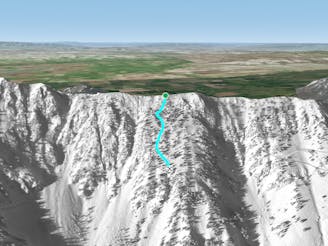
An awesomely complex run with open pow, exposure, billy goating, and pucker factor
Severe Freeride Skiing
- Distance
- 307 m
- Ascent
- 0 m
- Descent
- 229 m
Ropeline separating D Route from the rest of the ridge to the North
Freeride Skiing Difficult

This is a popular freeride skiing route which is generally considered to be difficult. It's remote, it features medium exposure (e2) and is typically done between November and April. From a low point of 2.5 km to the maximum altitude of 2.6 km, the route covers 105 m, 0 vertical metres of ascent and 79 vertical metres of descent. It's graded 3.2 and Labande grade 3.
The D Route ropeline separates D Route with the rest of the ridge terrain that lies to the North. Do not cross this ropeline unless the gate is open!
Difficult
Serious gradient of 30-38 degrees where a real risk of slipping exists.

As well as the slope itself, there are some obstacles (such as rock outcrops) which could aggravate injury.
Away from help but easily accessed.
13 m away
An awesomely complex run with open pow, exposure, billy goating, and pucker factor
Severe Freeride Skiing
84 m away

Steep, technical tree skiing
Severe Freeride Skiing
95 m away

Broad, steep finger ridge with technical sections
Severe Freeride Skiing
97 m away

Awesome long hourglass
Difficult Freeride Skiing
112 m away

Aesthetic South facing couloir with a technical exit
Difficult Freeride Skiing
113 m away

Long, steep, very narrow, hop turn chute with a straightline out the bottom
Severe Freeride Skiing
116 m away

Open mellow tree skiing to a tight, rocky, technical way into King's
Severe Freeride Skiing
146 m away

Very tight, steep, fast, straightline chute
Severe Freeride Skiing
159 m away

Mellow tree skiing to gnarly rocky South facing chute
Difficult Freeride Skiing
176 m away
Powder filled lower angle tree alleys
Difficult Freeride Skiing