13 m away
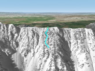
D Route Ropeline

Ropeline separating D Route from the rest of the ridge to the North
Difficult Freeride Skiing
- Distance
- 105 m
- Ascent
- 0 m
- Descent
- 79 m
An awesomely complex run with open pow, exposure, billy goating, and pucker factor
Freeride Skiing Severe

Green Jeans is the quintessential Bridger line. It has nice open pow turns, a traverse out, billy goating, exposure, trees, rocks, cliffs, and a tight gnarly exit into an open pow field. Go with somebody who has skied it before and know that you will be side stepping/ slipping on rocks above very large nasty cliffs. Plan on being humbled. The lower sections of Green Jeans can be sun affected, plan on some variable snow most of the year. Head past 6th Grade if you are coming from Schlasman's, or drop in just past the D Route gate if coming from Bridger. Ski the moderately steep powder as it funnels you down towards trees and into a tighter gulley. Ski into the gully until you see the obvious way out just to your right. After getting out of the gulley, you will have a few nice turns in a hanging snowfield, head just a little bit to your right to find the start of the gnarly traverse into the lower section. You will be on perch with 6th Grade to your right and gnarly cliffs and trees below you. Keep your composure and start making your way to the left. Be very careful here, a fall would have dire consequences. You will navigate a series of ledges as you go left until you see the bottom of Nun's. Once here, you can make the technical moves into the bottom of Nun's, or you can get on a series of spines that head fall line and to the left. Once through these moves, you will be into a large open powder field that is shared with the bottom of Colter's. Beware of anyone coming out of Colter's that may cut across into your path. You can also get into Green Jeans by skiing just left of 6th grade, through very steep trees, finding your way into the hanging snowfield that is immediately above the billy goat traverse.
Severe
Steep skiing at 38-45 degrees. This requires very good technique and the risk of falling has serious consequences.

As well as the slope itself, there are some obstacles (such as rock outcrops) which could aggravate injury.
Away from help but easily accessed.
13 m away
Ropeline separating D Route from the rest of the ridge to the North
Difficult Freeride Skiing
82 m away

Broad, steep finger ridge with technical sections
Severe Freeride Skiing
87 m away

Steep, technical tree skiing
Severe Freeride Skiing
101 m away

Aesthetic South facing couloir with a technical exit
Difficult Freeride Skiing
102 m away

Long, steep, very narrow, hop turn chute with a straightline out the bottom
Severe Freeride Skiing
102 m away

Open mellow tree skiing to a tight, rocky, technical way into King's
Severe Freeride Skiing
111 m away

Awesome long hourglass
Difficult Freeride Skiing
145 m away

Very tight, steep, fast, straightline chute
Severe Freeride Skiing
151 m away

Mellow tree skiing to gnarly rocky South facing chute
Difficult Freeride Skiing
189 m away
Powder filled lower angle tree alleys
Difficult Freeride Skiing