148 m away
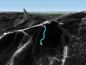
Roger's Chute

A fun little chute between National and Liftline.
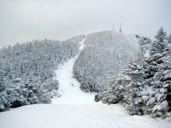
Moderate Freeride Skiing
- Distance
- 195 m
- Ascent
- 0 m
- Descent
- 81 m
found these with dad, really fun on pow days
Freeride Skiing Moderate

This is a popular freeride skiing route which is generally considered to be moderate. It's remote, it features low exposure (e1) and is typically done between December and March. From a low point of 646 m to the maximum altitude of 752 m, the route covers 319 m, 0 vertical metres of ascent and 106 vertical metres of descent.
found these with dad, really fun on pow days
Moderate
Slopes become slightly steeper at around 25-30 degrees.

Exposure is limited to that of the slope itself. Getting hurt is still likely if the slope is steep and/or the snow is hard.

Away from help but easily accessed.
148 m away
A fun little chute between National and Liftline.
Moderate Freeride Skiing
349 m away

An expert glade with an interesting history.
Moderate Freeride Skiing
516 m away

Popular woods between Upper National/Liftline and Starr
Difficult Freeride Skiing
654 m away
Very similar to Pipeline, with a different access point. Perfect for skiers looking for something tight and steep.
Difficult Freeride Skiing
668 m away

A Stowe Classic, Goat Glades is the popular glade to skiers left of Goat.
Moderate Freeride Skiing
703 m away

While it may not have any ledges, it does have plenty of room for turns.
Moderate Freeride Skiing
731 m away

The most relentless inbounds line at Stowe
Severe Freeride Skiing
768 m away

A popular patch of woods that are always fun to ski.
Moderate Freeride Skiing
883 m away

One of the oldest ski trails in the USA and a great run for advanced skiers.
Moderate Freeride Skiing
922 m away

A summer hiking trail that requires serious tree skiing skills to negotiate.
Moderate Freeride Skiing
12 routes · Freeride Skiing