424 m away
Butt Crack

A favorite backcountry zone among locals.
Moderate Freeride Skiing
- Distance
- 651 m
- Ascent
- 1 m
- Descent
- 221 m
Steep glade off of side street
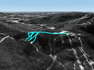
Freeride Skiing Difficult

This is a popular freeride skiing route which is generally considered to be difficult. It's remote, it features medium exposure (e2) and is typically done between December and March. From a low point of 598 m to the maximum altitude of 671 m, the route covers 264 m, 6 vertical metres of ascent and 72 vertical metres of descent.
When side street and ridge run merge, there should be a fairly flat opening into the trees. follow this path, where it is pretty mellow for 100 feet until it drops you down the face. this face is fairly steep, probably the steepest thing on this side of Stowe.
Difficult
Serious gradient of 30-38 degrees where a real risk of slipping exists.

As well as the slope itself, there are some obstacles (such as rock outcrops) which could aggravate injury.
Away from help but easily accessed.
424 m away
A favorite backcountry zone among locals.
Moderate Freeride Skiing
570 m away

A short little stash off Cross Cut #2
Moderate Freeride Skiing
1.3 km away

A low angle trail used to cross from Spruce Peak to Sterling Peak and to access the Back Bowls.
Easy Freeride Skiing
1.6 km away

A massive backcountry glade with a number of drop ins
Difficult Freeride Skiing
1.6 km away

Long, steep glade runs, involving cliffs and chutes.
Severe Freeride Skiing
2 km away
A short hike/sidestep some wide side country glades.
Difficult Freeride Skiing
2 km away

One of the most popular hardwood glades in The Notch
Moderate Freeride Skiing
2.1 km away

A frozen riverbed that’s almost as wide as a ski trail.
Moderate Freeride Skiing
2.1 km away

A handful of turns through unmarked woods.
Moderate Freeride Skiing
2.1 km away

A tight glade skiers right of Smugglers Alley.
Moderate Freeride Skiing
12 routes · Freeride Skiing