209 m away
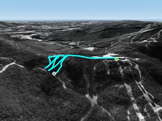
Freefall Glades

One of the hardest unmarked glades on the mountain.
Severe Freeride Skiing
- Distance
- 207 m
- Ascent
- 0 m
- Descent
- 80 m
A tight evergreen glade for expert skiers.
Freeride Skiing Moderate

To skiers right of F.I.S there’s a traverse into Doc Dempsey’s Glade. Below this traverse lies Taint, a tight little chute that drops down to Goat Path. In Upper Taint you are confined to a tight, almost single track glade. Lower Taint starts after you cross Goat Path and is a little more spacious. It also has more paths to choose from. Lower Taint ends on Mulcahy’s Link. Taint is the place to be on a powder day and locals will most likely be headed there early on.
Moderate
Slopes become slightly steeper at around 25-30 degrees.

As well as the slope itself, there are some obstacles (such as rock outcrops) which could aggravate injury.

Close to help in case of emergency.
209 m away
One of the hardest unmarked glades on the mountain.
Severe Freeride Skiing
379 m away

A short but steep face that terminates into tight trees.
Severe Freeride Skiing
452 m away

Short little stash off Lower Chilcoot.
Moderate Freeride Skiing
1.1 km away

The inbounds continuation of Hershey Highway.
Moderate Freeride Skiing
1.3 km away

A tight glade skiers right of Smugglers Alley.
Moderate Freeride Skiing
1.4 km away

A handful of turns through unmarked woods.
Moderate Freeride Skiing
1.6 km away
A short hike/sidestep some wide side country glades.
Difficult Freeride Skiing
2 km away

A massive backcountry glade with a number of drop ins
Difficult Freeride Skiing
2.4 km away

A low angle trail used to cross from Spruce Peak to Sterling Peak and to access the Back Bowls.
Easy Freeride Skiing
2.7 km away

A short little stash off Cross Cut #2
Moderate Freeride Skiing