200 m away
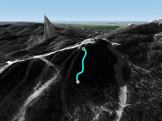
The Ledges

While it may not have any ledges, it does have plenty of room for turns.
Moderate Freeride Skiing
- Distance
- 292 m
- Ascent
- 0 m
- Descent
- 112 m
more rock drops this way
Freeride Skiing Moderate

This is a popular freeride skiing route which is generally considered to be moderate. It's not remote, it features low exposure (e1) and is typically done between January and March. From a low point of 671 m to the maximum altitude of 824 m, the route covers 545 m, 0 vertical metres of ascent and 153 vertical metres of descent.
An alternate route to tres amigos, but with more fun, medium size drops.
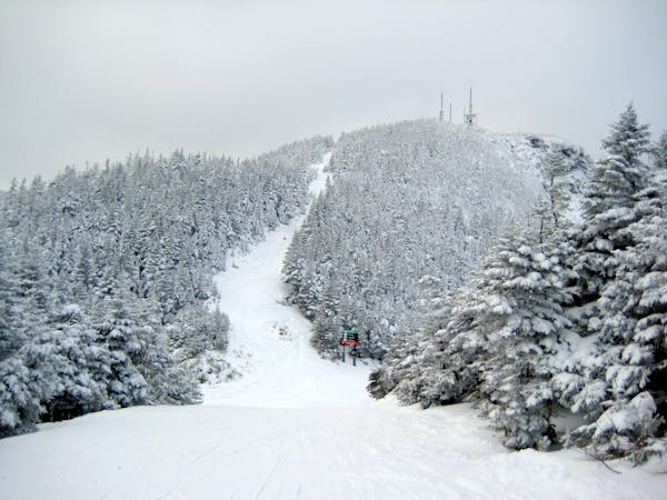
Moderate
Slopes become slightly steeper at around 25-30 degrees.

Exposure is limited to that of the slope itself. Getting hurt is still likely if the slope is steep and/or the snow is hard.
Close to help in case of emergency.
200 m away
While it may not have any ledges, it does have plenty of room for turns.
Moderate Freeride Skiing
244 m away

A popular patch of woods that are always fun to ski.
Moderate Freeride Skiing
517 m away

A fun little chute between National and Liftline.
Moderate Freeride Skiing
554 m away

Popular woods between Upper National/Liftline and Starr
Difficult Freeride Skiing
627 m away

An expert glade with an interesting history.
Moderate Freeride Skiing
861 m away
Very similar to Pipeline, with a different access point. Perfect for skiers looking for something tight and steep.
Difficult Freeride Skiing
943 m away

The most relentless inbounds line at Stowe
Severe Freeride Skiing
1 km away

A Stowe Classic, Goat Glades is the popular glade to skiers left of Goat.
Moderate Freeride Skiing
1.1 km away

One of the oldest ski trails in the USA and a great run for advanced skiers.
Moderate Freeride Skiing
1.2 km away

Steep chutes with trees and cliffs, accessed by a sidestepping traverse.
Difficult Freeride Skiing
12 routes · Freeride Skiing