8 routes · Hiking
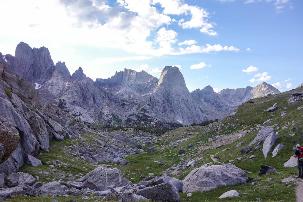
High alpine basin rimmed by huge granite spires in Wyoming's remote Wind River Range.
Hiking Difficult

Described is the shortest route into the Cirque of the Towers: In and out via Big Sandy Trail. The loop with Texas Pass is mentioned, but not detailed.
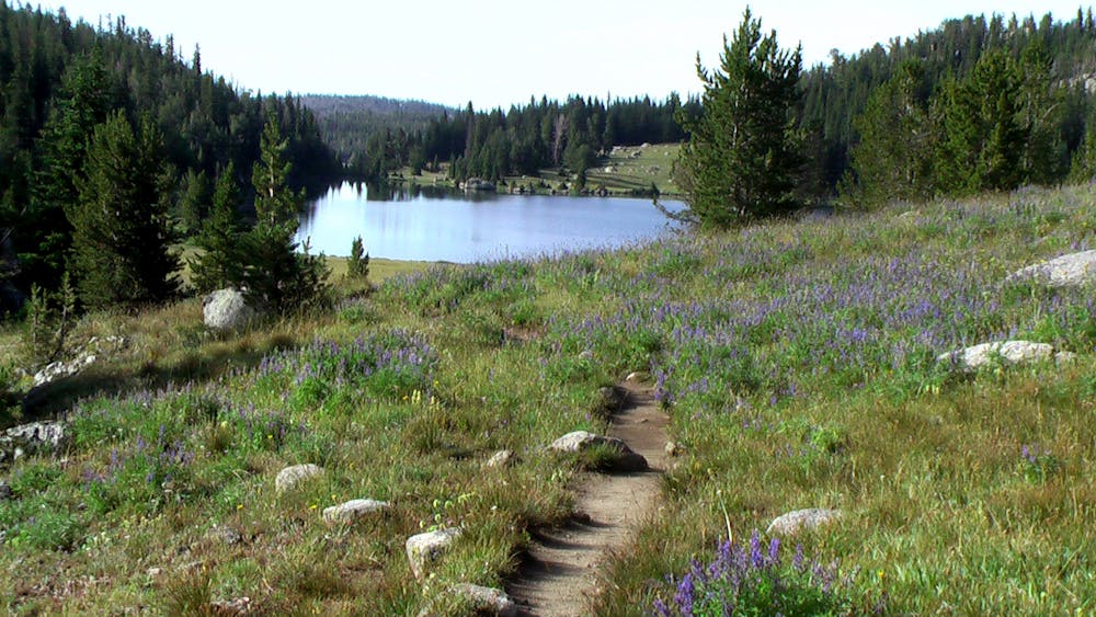
The trail starts out mellow, on a level ground among conifer forest beside the Big Sandy River. In less than half a mile it enters a wide meadow, where you’ll get a glimpse over the trees of the mountains to come. At 0.6 the trail comes to a junction where you’ll turn right to continue on Big Sandy Trail, following a sign for Sedgewick Meadow. It immediately crosses Meeks Creek where you may get your feet wet.
Note: Turning left, on the Continental Divide Trail, is the way to reach the Cirque via Shadow Lake and Texas Pass, which together with Big Sandy Trail makes the longer and less-traveled Cirque of the Towers Loop
From here the trail begins a gentle ascent, traversing the hillside just above the river through alternating forest and meadows, with the meadow gaps granting increasingly better views straight up the valley to the mountains ahead. The path is well traveled and easy to follow.
At just over 3 miles comes a junction with the trail to Diamond Lake. Take this if you wish for a quick side trip to view the first glacial lake along the way, but there are plenty more to come. Continue straight to stay on the main trail as it climbs and away from the river into a smaller, parallel drainage. Here you’ll encounter a few stream crossings and pass small ponds along the gently ascending, forested terrain. At 4.7 miles the trail makes a brief descent and breaks out of the trees for your first view of Big Sandy Lake.
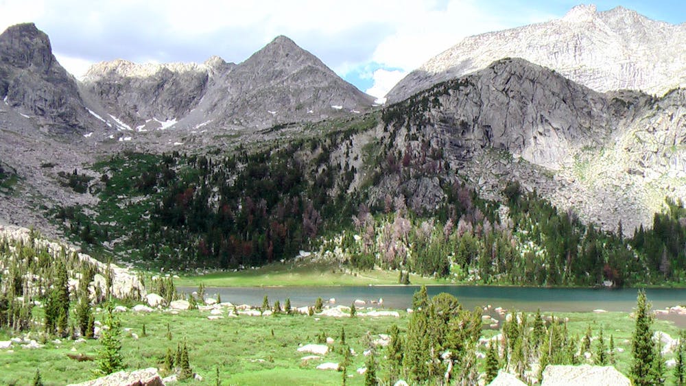
This is a fairly large lake tucked in the intersection of three steep valleys, and right at the foot of Big Sandy Mountain. As the trail follows the lake’s west shore, you’ll bask in views over the water to sheer cliffs and snowy bowls on the mountain’s slopes, its proud peak above, and summits of surrounding mountains poking up on both sides.
Big Sandy Lake is the target destination of some who hike this trail, and others base here to explore multiple day hikes. Thus, it is a popular place to camp. Good sites are easy to find near the lakeshore, or at the higher lakes just east of Big Sandy which the Continental Divide Trail Leads to. This trail branches off to the right at mile 5.5, next to Big Sandy Lakes norwest corner. Continue straight to head toward Jackass Pass and the Cirque. The trail immediately begins switchbacking up the steep valley of North Creek to climb into the mountains.
At 6.1 miles the trail crosses the creek and soon leaves the relative comfort of grass and trees for exposed, but gorgeous, boulder gardens and rock slabs. Here the trail gets harder to follow, but look closely for tracks and rock cairns and you’ll be able to follow it. It traverses above the clear water of North Lake, which pools surprisingly midway up this gorge. Wind around the top of the lake through a marshy meadow, then begin climbing through rocks again as the trail follows the west fork of the valley.
All the while, huge peaks ahead are growing bigger as you work your way closer, and the view down the valley to peaks behind gets even better as you gain higher vantage. The trek feels more and more alpine as you work your way up, with granite walls becoming steeper all around, boulders in the trail bigger and tougher to negotiate, and the weather more likely to be windy and cold. You may even cross patches of snow during early summer.
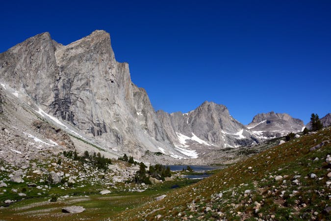
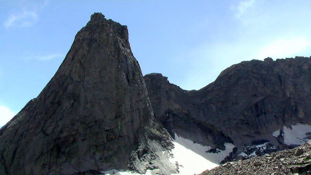
Stick to the creek’s east side and follow the path of least resistance up and up. The trail follows a sloped bench to a point high above the valley floor. Venture to the edge for a stunning view of Arrowhead Lake directly below and Warbonnet Peak towering above. This point (mile 7.6) also grants your first view into the Cirque, with granite pinnacles visible through the pass dead ahead.
The Cirque is close, but some work remains to reach it. The trail leads steeply down from this highpoint above Arrowhead Lake to rejoin the bottom of the gorge then climb the opposite side, about 300 feet to Jackass Pass. That tantalizing view of the Cirque’s summits disappears, but comes back a hundred times better once you reach the pass, at mile 8.2. Then it’s all there in full splendor--a ring of massive granite spires around a green-carpeted valley and the shimmering blue of Lonesome Lake in the center of it all. Pause to take in the glorious view from here, the trail’s highpoint at 10,790 feet.
Steep switchbacks lead down from the pass through more boulders and rocky meadows, but the terrain eases in about half a mile as you near the bottom of the basin. You’ll reach a junction with the trail that loops around Lonesome Lake, and choose to go left or right to find a campsite. Camping is allowing throughout the Cirque, except within a quarter mile of Lonesome Lake. You should try to remain at least 200 feet of all water sources in order to minimize your impact, and use only spots that have clearly been used before.
Good sites can be found on the rocky meadow benches above Lonesome Lake, or at forest edge farther down the outlet stream, or near the surrounding smaller lakes higher in the basin. Spur trails lead to these lakes and various viewpoints throughout the Cirque.
Note: The unofficial trail to Texas Pass begins from the north shore of Lonesome Lake. This is the route that can be used to complete a loop in and out of the Cirque with Shadow Lake and the Continental Divide Trail.
Sources: http://www.cleverhiker.com/blog/cirque-of-the-towers-3-day-backpacking-loop-wind-river-wy http://www.hikingwalking.com/index.php/destinations/wy/wyww/bigsandy/bigsandyctrt
Difficult
Hiking trails where obstacles such as rocks or roots are prevalent. Some obstacles can require care to step over or around. At times, the trail can be worn and eroded. The grade of the trail is generally quite steep, and can often lead to strenuous hiking.

Some trail sections are extremely exposed where falling will almost certainly result in serious injury or death.

Little chance of being seen or helped in case of an accident.
8 routes · Hiking
5 routes · Alpine Climbing · Hiking