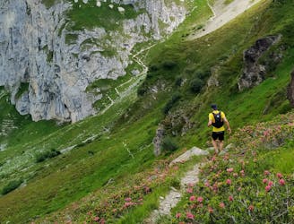
Panorama Trail by Vorab Glacier
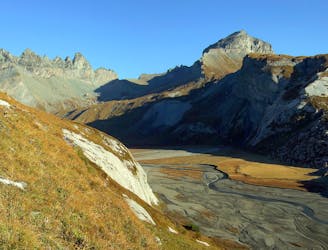
For a high altitude trail run with 360 degree views of Graubünden’s glorious mountain vistas, try the Panorama Trail.
Difficult Trail Running
- Distance
- 12 km
- Ascent
- 509 m
- Descent
- 606 m

Go trail running in Graubünden with curated guides of the best trail runs across the region. With over 161 3D trail maps in FATMAP, you can easily discover and navigate the best trails in Graubünden.
No matter what your next adventure has in store, you can find a guide on FATMAP to help you plan your next epic trip.
Get a top trail running recommendation in Graubünden from one of our 20 guidebooks, or get inspired by the 161 local adventures uploaded by the FATMAP community. Start exploring now!
For a high altitude trail run with 360 degree views of Graubünden’s glorious mountain vistas, try the Panorama Trail.
Difficult Trail Running
Hochalpin, technisch und die ideale Vorbereitung auf den T54 im Folgejahr
Moderate Trail Running
Der perfekte Einstieg in die Welt des Trailrunnings mit dem besten Panorama
Easy Trail Running
Alpiner & technischer Trailrun vor spektakulärer Kulisse
Severe Trail Running
360° Panorama Trail über der Talsohle von Klosters
Moderate Trail Running

Going from Soleval and back
Severe Trail Running

Tour Heidiland 2021 Etappe
Moderate Trail Running

Tour Heidiland 2021 Etappe
Difficult Trail Running

Trail Marathon from Switzerland across Liechtenstein into Austria. Mostly on single trails and on ridges with spectacular views.
Severe Trail Running
Flowy single trails, alps with cows and the smallest cable car in the Canton!
Difficult Trail Running
Challenging trails through varied terrain and stunning ridges along the Swiss / Austrian border
Severe Trail Running