Anello dell'Agner

Giro ad anello del gruppo dell'Agner con doppia ferrata e pernottamento al bivacco Reali
Severe Hiking
- Distance
- 19 km
- Ascent
- 2.8 km
- Descent
- 1.9 km
Explore Belluno with curated guides of the best hiking trails, mountain bike trails, trail running routes, ski routes, and more. With over 273 3D trail maps in FATMAP, you can easily discover and navigate the best trails in Belluno.
No matter what your next adventure has in store, you can find a guide on FATMAP to help you plan your next epic trip.
Get a top trail recommendation in Belluno from one of our 18 guidebooks, or get inspired by the 273 local adventures uploaded by the FATMAP community. Start exploring now!
Giro ad anello del gruppo dell'Agner con doppia ferrata e pernottamento al bivacco Reali
Severe Hiking

Dolomiti - Lago di Federa / Croda da Lago
Moderate Hiking

Dolomiti - Passo Giau - Lago della Baste - Monte Corvo
Moderate Hiking
Anello del Pelmo [antiorario] - (Rifugio Staulanza, rifugio Venezia, Val d'Arcia)
Difficult Hiking

Needs good skills and training
Severe Hiking
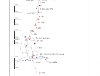
New route on South Face of Cima Grande, bolted by Cristoph Hainz and Gerda Schwienbacher by 08.06.2019
Difficult Alpine Climbing
Partenza da parcheggio San Uberto
Moderate Hiking

Van de Pale di San Martino over de Vette Feltrine.
Difficult Hiking

ALTA VIA 1 - STAGE 11 - RIFUGIO PIAN DI FONTANA to Le Pissa Bus Stop (END)
Difficult Hiking

ALTA VIA 1 - STAGE 10 - SEPT 13th RIFUGIO PIAN DI FONTANA - Bunk Room HB
Difficult Hiking

ALTA VIA 1 - STAGE 7 - SEPT 10th RIFUGIO VAZZOLER - Private Room HB
Easy Hiking

ALTA VIA 1 - STAGE 11 - RIFUGIO PIAN DI FONTANA to Le Pissa Bus Stop (END)
Moderate Hiking

ALTA VIA 1 - STAGE 10 - RIFUGIO PRAMPERET TO RIFUGIO PIAN DI FONTANA
Moderate Hiking

ALTA VIA 1 - STAGE 9 - RIFUGIO CARESTIATO TO RIFUGIO PRAMPERET
Moderate Hiking

ALTA VIA 1 - STAGE 8 - RIFUGIO VAZZOLER TO RIFUGIO CARESTIATO
Moderate Hiking

ALTA VIA 1 - STAGE 7 - RIFUGIO TISSI TO RIFUGIO VAZZOLER
Moderate Hiking