449 m away
Middle Needle Peak
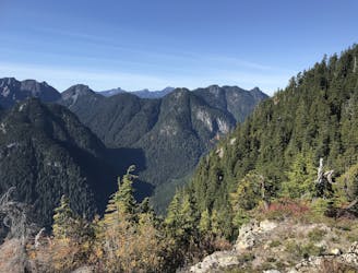
Follow a heavily forested ridge to one of Vancouver's lesser known peaks
Moderate Hiking
- Distance
- 20 km
- Ascent
- 1.5 km
- Descent
- 1.5 km
Go up to Lynn Balloon Lookout, signs say Lynn Peak (it is not a peak)
Hiking Moderate

This is a popular hiking route which is generally considered to be moderate. It's not remote, it features low exposure and is typically done between June and October. From a low point of 191 m to the maximum altitude of 930 m, the route covers 7.9 km, 749 vertical metres of ascent and 749 vertical metres of descent.
Great trail, first 50-60 minutes is climbing on large rocks/boulders
Moderate
Hiking along trails with some uneven terrain and small hills. Small rocks and roots may be present.

The path is on completely flat land and potential injury is limited to falling over.
Close to help in case of emergency.
449 m away
Follow a heavily forested ridge to one of Vancouver's lesser known peaks
Moderate Hiking
5.8 km away
A scrambly hike to the summit of Mt. Seymour
Difficult Hiking
9.1 km away
Short distance, low elevation, great views
Easy Hiking

7 routes · Hiking · Trail Running

6 routes · Hiking

3 routes · Hiking