686 m away
Grau Roig far West

Classic freeride lines out of the resort boundaries
Moderate Freeride Skiing
- Distance
- 1.2 km
- Ascent
- 0 m
- Descent
- 286 m
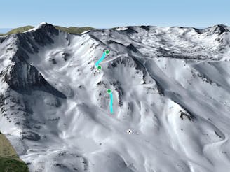
Freeride lines for resort hikers
Freeride Skiing Moderate

If you are riding the resort you can get up to Costa Rodona chairlift and ride down to the mountain road pass and cross the road. On the far left side (coming down from Costa Rodona), or on the road way to Grau Roig, there is a parking. From there you can start hiking up to the top right. A hike which will take you as much as 35 min on foot and deep snow. From there drop into the bowl leaving the ridge on your right. It's as well rideable but often the snow gets blown up. Ride down to the more rolling area ahead. From the top of the rolling hill turn right to the steep section and point for your meeting spot on the road. Get as close as you can to the crossing where the town road intersects the main road. From there you can walk or make it back down to the village.
Moderate
Slopes become slightly steeper at around 25-30 degrees.

Exposure is limited to that of the slope itself. Getting hurt is still likely if the slope is steep and/or the snow is hard.

Little chance of being seen or helped in case of an accident.
686 m away
Classic freeride lines out of the resort boundaries
Moderate Freeride Skiing
1.1 km away

Freeride lines for resort hikers
Difficult Freeride Skiing
1.2 km away

Backcountry route for experienced riders
Difficult Freeride Skiing
1.4 km away

Wide steep riding from Coll Blanc
Moderate Freeride Skiing
1.8 km away

Short, technical and steep couloirs
Severe Freeride Skiing
1.9 km away
A steep line through rocky terrain for experienced riders
Difficult Freeride Skiing
2 km away

Popular off piste with terrain with easy access.
Severe Freeride Skiing
2.1 km away

An open terrain freeride area
Moderate Freeride Skiing
2.4 km away

Steep couloirs for experienced riders
Difficult Freeride Skiing
2.4 km away

Technical and challenging lines on the Pic Blanc North-west face.
Severe Freeride Skiing
22 routes · Freeride Skiing